
Gracias por apoyar a este sitio ❤️
Haz una donación
Haz una donación
Mapa topográfico Polkton Township
Haga clic en el mapa para ver la altitud.
Gracias por apoyar a este sitio ❤️
Haz una donación
Haz una donación
Acerca de este mapa
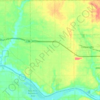
Nombre: Mapa topográfico Polkton Township, altitud, relieve.
Lugar: Polkton Township, Ottawa County, Michigan, United States (43.00166 -86.02702 43.11886 -85.90674)
Altitud media: 195 m
Altitud mínima: 175 m
Altitud máxima: 228 m
Gracias por apoyar a este sitio ❤️
Haz una donación
Haz una donación
Otros mapas topográficos
Haga clic en un mapa para ver su topografía, su altitud y su relieve.
Gracias por apoyar a este sitio ❤️
Haz una donación
Haz una donación
Gracias por apoyar a este sitio ❤️
Haz una donación
Haz una donación