
Haz una donación
Mapa topográfico Catoctin Mountain
Haga clic en el mapa para ver la altitud.
Haz una donación
Catoctin Mountain
Catoctin Mountain traverses Frederick County, Maryland and extends into northern Loudoun County, Virginia. It rises to its greatest elevation of 1,900 feet (580 m) above sea level just southwest of Cunningham Falls State Park and is transected by gaps at Braddock Heights (Fairview Pass), Point of Rocks on the Potomac River and Clarke's Gap west of Leesburg, as well as several other unnamed passes in Maryland and Virginia. The mountain is much lower in elevation in Virginia, reaching its highest peak just south of the Potomac at Furnace Mountain (891 feet/271 m) and with only one peak above 800 feet (240 m) south of Leesburg.
Haz una donación
Acerca de este mapa
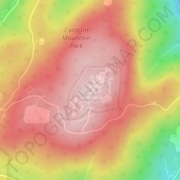
Nombre: Mapa topográfico Catoctin Mountain, altitud, relieve.
Altitud media: 471 m
Altitud mínima: 271 m
Altitud máxima: 574 m
Haz una donación
Otros mapas topográficos
Haga clic en un mapa para ver su topografía, su altitud y su relieve.
Haz una donación
Braddock Heights
United States > Maryland > Frederick County > Braddock Heights
Braddock Heights is located at an elevation of 950 feet (290 m) atop Braddock Mountain (as Catoctin Mountain is locally known) near the pass at Braddock Springs, so named after British General Edward Braddock and Lt. Colonel George Washington's use of the mountain pass on their way to Fort Duquesne during the…
Altitud media: 179 m
Haz una donación
Haz una donación
Haz una donación
Haz una donación
Haz una donación
Haz una donación