
Haz una donación
Mapa topográfico Clover Hill
Haga clic en el mapa para ver la altitud.
Haz una donación
Acerca de este mapa
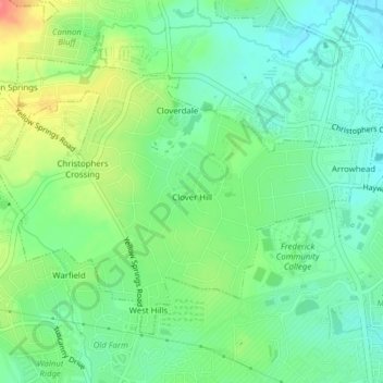
Nombre: Mapa topográfico Clover Hill, altitud, relieve.
Lugar: Clover Hill, Frederick County, Maryland, United States (39.44544 -77.44931 39.46783 -77.41043)
Altitud media: 111 m
Altitud mínima: 86 m
Altitud máxima: 157 m
Haz una donación
Otros mapas topográficos
Haga clic en un mapa para ver su topografía, su altitud y su relieve.
Highland
United States > Maryland > Frederick County
The majority of the downtown Highland district is situated within the 418-acre (169 ha) land grant named "Hickory Ridge". The Rouse Company borrowed the land grant name for one of its nearby villages of Columbia, built in 1974. The historic "White Hall" or "Hickory Ridge" estate (1749) was owned by the…
Altitud media: 357 m
Haz una donación
Haz una donación
Catoctin Mountain
United States > Maryland > Frederick County
Catoctin Mountain traverses Frederick County, Maryland and extends into northern Loudoun County, Virginia. It rises to its greatest elevation of 1,900 feet (580 m) above sea level just southwest of Cunningham Falls State Park and is transected by gaps at Braddock Heights (Fairview Pass), Point of Rocks on the…
Altitud media: 471 m
Haz una donación
Highland
United States > Maryland > Frederick County
The majority of the downtown Highland district is situated within the 418-acre (169 ha) land grant named "Hickory Ridge". The Rouse Company borrowed the land grant name for one of its nearby villages of Columbia, built in 1974. The historic "White Hall" or "Hickory Ridge" estate (1749) was owned by the…
Altitud media: 357 m
Haz una donación
Haz una donación
West Frederick Highlands
United States > Maryland > Frederick County > Ballenger Creek
Altitud media: 113 m
Haz una donación
Colonial Heights
United States > Maryland > Frederick County > Thurmont > Colonial Heights
Altitud media: 157 m
Haz una donación
Mount Airy Estates
United States > Maryland > Frederick County > Mount Airy Estates
Altitud media: 161 m
Haz una donación