
Haz una donación
Mapa topográfico Gist
Haga clic en el mapa para ver la altitud.
Haz una donación
Acerca de este mapa
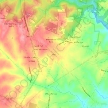
Nombre: Mapa topográfico Gist, altitud, relieve.
Lugar: Gist, Carroll County, Maryland, United States (39.43066 -77.00970 39.47066 -76.96970)
Altitud media: 203 m
Altitud mínima: 143 m
Altitud máxima: 251 m
Haz una donación
Otros mapas topográficos
Haga clic en un mapa para ver su topografía, su altitud y su relieve.
Westminster
United States > Maryland > Carroll County
Westminster lies in the humid subtropical climate zone, with hot and humid summers and cool winters with highly variable seasonal snowfall. Due to its elevation, distance from the Chesapeake Bay and urban heat island, temperatures in Westminster are often considerably lower than in Baltimore, especially at…
Altitud media: 226 m
Mount Airy
United States > Maryland > Carroll County
The town was originally settled in the early 1830s by a core group of six families. Dorsey, Davis and Bussard were the most prominent names in that first settlement, which was followed closely by the construction of the B & O railroad line in 1831. Because Mount Airy sits at an elevation of 830 feet (250 m), a…
Altitud media: 221 m
Haz una donación
Haz una donación
Mount Airy
United States > Maryland > Carroll County
The town was originally settled in the early 1830s by a core group of six families. Dorsey, Davis and Bussard were the most prominent names in that first settlement, which was followed closely by the construction of the B & O railroad line in 1831. Because Mount Airy sits at an elevation of 830 feet (250 m), a…
Altitud media: 221 m
Haz una donación
Westminster
United States > Maryland > Carroll County
Westminster lies in the humid subtropical climate zone bordering on a humid continental climate, with hot and humid summers and cool winters with highly variable seasonal snowfall. Due to its elevation, distance from the Chesapeake Bay and urban heat island, temperatures in Westminster are often considerably…
Altitud media: 228 m