Geolocalizar

Mapa topográfico Mount Airy

Mapa interactivo

Haga clic en el mapa para ver la altitud.

Acerca de este mapa

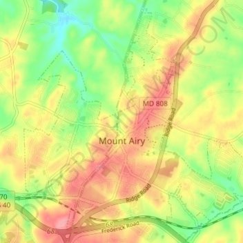
Nombre: Mapa topográfico Mount Airy, altitud, relieve.

Lugar: Mount Airy, Carroll County, Maryland, 21771, United States (39.35936 -77.17936 39.40122 -77.11890)

Altitud media: 221 m

Altitud mínima: 169 m

Altitud máxima: 269 m

The town was originally settled in the early 1830s by a core group of six families. Dorsey, Davis and Bussard were the most prominent names in that first settlement, which was followed closely by the construction of the B & O railroad line in 1831. Because Mount Airy sits at an elevation of 830 feet (250 m), a series of four inclined planes were constructed in order for the trains to climb the steep hills. Locomotives and cars were lifted with the assistance of horses and steam winches. Passengers had to disembark during this process. Plane #4, located west of the town at the intersection of Woodville Road and MD Route 144, is still a recognized location today. In 1839 the planes were abandoned, and the new line was constructed north of where Mount Airy is today. This was a result of more powerful locomotives that had been constructed and heavier loads were being hauled. In 1901, a railroad tunnel was constructed on the south side of town and the existing line into town became a spur line into the center of Mount Airy. The town named the first resident, Henry Bussard, the station agent for the new train station. Mr. Bussard was the first major landowner in Mount Airy.

Wikipedia (CC-BY-SA 3.0)

Otros mapas topográficos

Haga clic en un mapa para ver su topografía, su altitud y su relieve.

Bear Branch

United States > Maryland > Carroll County > Brown Heights

Bear Branch, Brown Heights, Carroll County, Maryland, United States

Altitud media: 145 m

Belle Grove Square

United States > Maryland > Carroll County > Westminster

Belle Grove Square, Westminster, Carroll County, Maryland, 21157, United States

Altitud media: 224 m

Finksburg

United States > Maryland > Carroll County

Finksburg, Carroll County, Maryland, 21048, United States

Altitud media: 158 m

Hampstead

United States > Maryland > Carroll County

Hampstead, Carroll County, Maryland, United States

Altitud media: 242 m

New Windsor

United States > Maryland > Carroll County

New Windsor, Carroll County, Maryland, United States

Altitud media: 154 m

Eldersburg

United States > Maryland > Carroll County

Eldersburg, Carroll County, Maryland, 21784, United States

Altitud media: 166 m

Keymar

United States > Maryland > Carroll County

Keymar, Carroll County, Maryland, 21757, United States

Altitud media: 128 m

Gaither

United States > Maryland > Carroll County

Gaither, Carroll County, Maryland, 21784, United States

Altitud media: 161 m

Union Bridge

United States > Maryland > Carroll County

Union Bridge, Carroll County, Maryland, United States

Altitud media: 138 m

Avondale Wildlife Management Area

United States > Maryland > Carroll County > Chapel Heights

Avondale Wildlife Management Area, Chapel Heights, Carroll County, Maryland, United States

Altitud media: 206 m

Melrose

United States > Maryland > Carroll County

Melrose, Carroll County, Maryland, United States

Altitud media: 262 m

Heritage

United States > Maryland > Carroll County

Heritage, Carroll County, Maryland, United States

Altitud media: 214 m

Washington Heights

United States > Maryland > Carroll County > Westminster

Washington Heights, Westminster, Carroll County, Maryland, 21157, United States

Altitud media: 233 m

Taneytown

United States > Maryland > Carroll County

Taneytown, Carroll County, Maryland, 21787, United States

Altitud media: 153 m

Millers

United States > Maryland > Carroll County

Millers, Carroll County, Maryland, 21102, United States

Altitud media: 266 m

Union Mills Homestead Park

United States > Maryland > Carroll County > Union Mills

Union Mills Homestead Park, Union Mills, Carroll County, Maryland, United States

Altitud media: 195 m

Furnace Hills

United States > Maryland > Carroll County > Westminster

Furnace Hills, Westminster, Carroll County, Maryland, 21157, United States

Altitud media: 211 m

Marston

United States > Maryland > Carroll County

Marston, Carroll County, Maryland, 21776, United States

Altitud media: 189 m

Liberty Reservoir

United States > Maryland > Carroll County

Liberty Reservoir, Carroll County, Maryland, United States

Altitud media: 170 m

Cape Horn South

United States > Maryland > Carroll County

Cape Horn South, Carroll County, Maryland, United States

Altitud media: 256 m

Meadow Brook

United States > Maryland > Carroll County > Taneytown

Meadow Brook, Taneytown, Carroll County, Maryland, 21787, United States

Altitud media: 156 m

Woodbine

United States > Maryland > Carroll County

Woodbine, Carroll County, Maryland, 21797, United States

Altitud media: 182 m

Mill Stream Hills

United States > Maryland > Carroll County

Mill Stream Hills, Carroll County, Maryland, 21088, United States

Altitud media: 238 m

Silver Run

United States > Maryland > Carroll County

Silver Run, Carroll County, Maryland, United States

Altitud media: 198 m

Eldersburg

United States > Maryland > Carroll County > Eldersburg

Eldersburg, Carroll County, Maryland, 21784, United States

Altitud media: 167 m

Forest Hills

United States > Maryland > Carroll County > Forest Hills

Forest Hills, Carroll County, Maryland, 21157, United States

Altitud media: 227 m

Manchester

United States > Maryland > Carroll County

Manchester, Carroll County, Maryland, United States

Altitud media: 276 m

Westminster

United States > Maryland > Carroll County

Westminster, Carroll County, Maryland, United States

Altitud media: 226 m

Mount Airy

United States > Maryland > Carroll County > Mount Airy > Mount Airy

Mount Airy, Carroll County, Maryland, 21771, United States

Altitud media: 217 m

Sykesville

United States > Maryland > Carroll County

Sykesville, Carroll County, Maryland, United States

Altitud media: 152 m

Piney Creek

United States > Maryland > Carroll County

Piney Creek, Carroll County, Maryland, 21787, United States

Altitud media: 152 m