
Mapa topográfico Pico de Orizaba
Mapa interactivo
Haga clic en el mapa para ver la altitud.
Acerca de este mapa
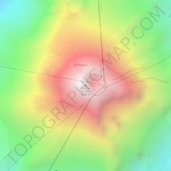
Nombre: Mapa topográfico Pico de Orizaba, altitud, relieve.
Lugar: Pico de Orizaba, Chalchicomula de Sesma, Puebla, Mexico (19.03024 -97.26986 19.03034 -97.26976)
Altitud media: 4.967 m
Altitud mínima: 4.327 m
Altitud máxima: 5.589 m
Pico de Orizaba, also known as Citlaltépetl (from Nahuatl citlal(in) = star, and tepētl = mountain), is an active stratovolcano, the highest mountain in Mexico and third highest in North America, after Denali of United States and Mount Logan of Canada. Pico de Orizaba is also the highest volcano in North America. It rises 5,636 metres (18,491 ft) above sea level in the eastern end of the Trans-Mexican Volcanic Belt, on the border between the states of Veracruz and Puebla. The volcano is currently dormant but not extinct, with the last eruption taking place during the 19th century. It is the second most prominent volcanic peak in the world after Mount Kilimanjaro. Pico de Orizaba is ranked 16th by topographic isolation.
Otros mapas topográficos
Haga clic en un mapa para ver su topografía, su altitud y su relieve.
Sierra Negra
Mexico > Puebla > Chalchicomula de Sesma
Sierra Negra, Chalchicomula de Sesma, Puebla, Mexico
Altitud media: 4.099 m