
Mapa topográfico Sierra Negra
Mapa interactivo
Haga clic en el mapa para ver la altitud.
Acerca de este mapa
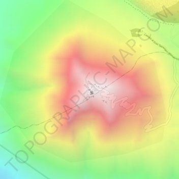
Nombre: Mapa topográfico Sierra Negra, altitud, relieve.
Lugar: Sierra Negra, Chalchicomula de Sesma, Puebla, Mexico (18.98616 -97.31515 18.98626 -97.31505)
Altitud media: 4.099 m
Altitud mínima: 3.534 m
Altitud máxima: 4.575 m
Sierra Negra is located within the Pico de Orizaba National Park. The mountain is the site for two of the world's premier astronomical instruments, the Large Millimeter Telescope and the High Altitude Water Cherenkov Observatory. Therefore, the access to the mountain is restricted and has to be applied for at least a week in advance. The service road for this facility is claimed to be the highest road in North America. A part of the telescope facility is visible as a white dot in the first picture below and more clearly in the second picture.
Otros mapas topográficos
Haga clic en un mapa para ver su topografía, su altitud y su relieve.
Pico de Orizaba
Mexico > Puebla > Chalchicomula de Sesma
Pico de Orizaba, Chalchicomula de Sesma, Puebla, Mexico
Altitud media: 4.967 m