
Gracias por apoyar a este sitio ❤️
Haz una donación
Haz una donación
Mapa topográfico Six Mile Cove
Haga clic en el mapa para ver la altitud.
Gracias por apoyar a este sitio ❤️
Haz una donación
Haz una donación
Acerca de este mapa
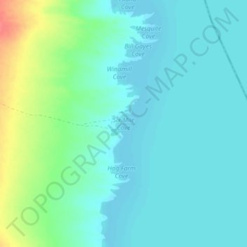
Nombre: Mapa topográfico Six Mile Cove, altitud, relieve.
Lugar: Six Mile Cove, Clark County, Nevada, United States (35.45300 -114.67808 35.45310 -114.67798)
Altitud media: 208 m
Altitud mínima: 194 m
Altitud máxima: 255 m
Gracias por apoyar a este sitio ❤️
Haz una donación
Haz una donación
Otros mapas topográficos
Haga clic en un mapa para ver su topografía, su altitud y su relieve.
Blue Diamond
United States > Nevada > Clark County
Blue Diamond is the site of Cottonwood Spring (formerly known as Ojo de Cayetana, or Pearl Spring), a watering place and camp site on the Old Spanish Trail and the later Mormon Road between Mountain Springs and Las Vegas Springs. The springs are located on a mountainside south of the town at 36°02′44″N…
Altitud media: 1.110 m
Gracias por apoyar a este sitio ❤️
Haz una donación
Haz una donación