
Gracias por apoyar a este sitio ❤️
Haz una donación
Haz una donación
Mapa topográfico Blue Diamond
Haga clic en el mapa para ver la altitud.
Gracias por apoyar a este sitio ❤️
Haz una donación
Haz una donación
Blue Diamond
Blue Diamond is the site of Cottonwood Spring (formerly known as Ojo de Cayetana, or Pearl Spring), a watering place and camp site on the Old Spanish Trail and the later Mormon Road between Mountain Springs and Las Vegas Springs. The springs are located on a mountainside south of the town at 36°02′44″N 115°24′22″W / 36.04556°N 115.40611°W / 36.04556; -115.40611 at an elevation of 3409 feet.
Gracias por apoyar a este sitio ❤️
Haz una donación
Haz una donación
Acerca de este mapa
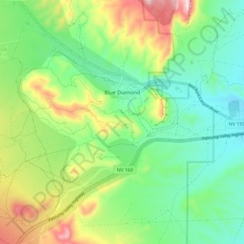
Nombre: Mapa topográfico Blue Diamond, altitud, relieve.
Lugar: Blue Diamond, Clark County, Nevada, 89004, United States (36.00962 -115.44477 36.06589 -115.35870)
Altitud media: 1.110 m
Altitud mínima: 963 m
Altitud máxima: 1.402 m
Gracias por apoyar a este sitio ❤️
Haz una donación
Haz una donación
Otros mapas topográficos
Haga clic en un mapa para ver su topografía, su altitud y su relieve.