
Haz una donación
Mapa topográfico Stow
Haga clic en el mapa para ver la altitud.
Haz una donación
Stow
On New Year's Day, 1984, Kevin Walsh took off from Minute Man Air Field with 57 helium balloons tied to a lawn chair, later descending by parachute. He was cited with four violations of FAA regulations and fined $4,000 ($10,922.66 adjusted for inflation to 2022). He reached an altitude of 9,000 feet (2,700 m).
Haz una donación
Acerca de este mapa
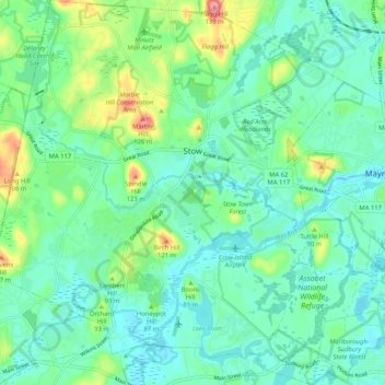
Nombre: Mapa topográfico Stow, altitud, relieve.
Lugar: Stow, Middlesex County, Massachusetts, 01775, United States (42.39003 -71.55910 42.46646 -71.46433)
Altitud media: 72 m
Altitud mínima: 50 m
Altitud máxima: 137 m
Haz una donación
Otros mapas topográficos
Haga clic en un mapa para ver su topografía, su altitud y su relieve.
Haz una donación
Haz una donación
Haz una donación
Medford Hillside
United States > Massachusetts > Middlesex County > Medford > West Medford
Altitud media: 13 m
Haz una donación
Winchester Highlands
United States > Massachusetts > Middlesex County > Winchester
Altitud media: 35 m
Haz una donación
Haz una donación
Haz una donación
Haz una donación
Haz una donación
Haz una donación
Hobbs Road
United States > Massachusetts > Middlesex County > Wayland > Cochituate
Altitud media: 66 m
Haz una donación
Haz una donación
Haz una donación
Haz una donación
Cambridge
United States > Massachusetts > Middlesex County > Cambridge
Cambridge obtains water from Hobbs Brook (in Lincoln and Waltham) and Stony Brook (Waltham and Weston), as well as an emergency connection to the Massachusetts Water Resources Authority. The city owns over 1,200 acres (486 ha) of land in other towns that includes these reservoirs and portions of their…
Altitud media: 31 m
Haz una donación
Weston Station
United States > Massachusetts > Middlesex County > Weston > Weston Station
Altitud media: 55 m
Haz una donación