
Mapa topográfico Winder
Mapa interactivo
Haga clic en el mapa para ver la altitud.
Acerca de este mapa
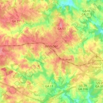
Nombre: Mapa topográfico Winder, altitud, relieve.
Lugar: Winder, Barrow County, Georgia, United States (33.93640 -83.76620 34.03697 -83.68046)
Altitud media: 274 m
Altitud mínima: 221 m
Altitud máxima: 322 m
Otros mapas topográficos
Haga clic en un mapa para ver su topografía, su altitud y su relieve.
Fort Yargo State Park
United States > Georgia > Barrow County > Winder
Fort Yargo State Park, Winder, Barrow County, Georgia, United States
Altitud media: 270 m
Auburn
United States > Georgia > Barrow County
Auburn, Barrow County, Georgia, 30011, United States
Altitud media: 300 m
Statham
United States > Georgia > Barrow County
Statham, Barrow County, Georgia, United States
Altitud media: 261 m
Carl
United States > Georgia > Barrow County
Carl, Barrow County, Georgia, United States
Altitud media: 317 m
Russell
United States > Georgia > Barrow County
Russell, Barrow County, Georgia, 30680, United States
Altitud media: 279 m
Bethlehem
United States > Georgia > Barrow County
Bethlehem, Barrow County, Georgia, United States
Altitud media: 258 m