
Haz una donación
Mapa topográfico Independence
Haga clic en el mapa para ver la altitud.
Haz una donación
Acerca de este mapa
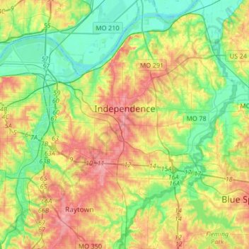
Nombre: Mapa topográfico Independence, altitud, relieve.
Lugar: Independence, Jackson County, Missouri, United States (39.01768 -94.48150 39.13987 -94.21601)
Altitud media: 261 m
Altitud mínima: 215 m
Altitud máxima: 330 m
Haz una donación
Otros mapas topográficos
Haga clic en un mapa para ver su topografía, su altitud y su relieve.
Richard L. Berkley Riverfront Park
United States > Missouri > Jackson County > Kansas City
Altitud media: 242 m
Haz una donación
Blue Springs Quad Number 1 Dam
United States > Missouri > Jackson County > Lee's Summit
Altitud media: 266 m
Haz una donación
Downtown Kansas City
United States > Missouri > Jackson County > Downtown Kansas City
Altitud media: 271 m
Haz una donación
Lee's Summit
United States > Missouri > Jackson County > Lee's Summit
When the surveyors for the Missouri Pacific Railroad came through, the local people and the railroad wanted to name the town in Dr. Lea's honor. He had a farm on the highest point and near the path of the tracks, and his murder had taken place near the site of the proposed depot. So they chose the name of…
Altitud media: 288 m