
Haz una donación
Mapa topográfico Cobbler
Haga clic en el mapa para ver la altitud.
Haz una donación
Acerca de este mapa
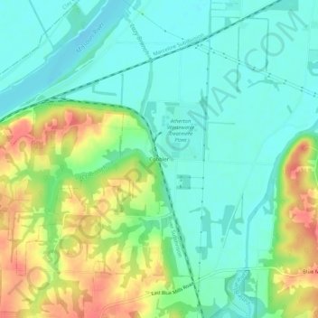
Nombre: Mapa topográfico Cobbler, altitud, relieve.
Lugar: Cobbler, Jackson County, Missouri, 64058, United States (39.14362 -94.34828 39.18362 -94.30828)
Altitud media: 237 m
Altitud mínima: 215 m
Altitud máxima: 279 m
Haz una donación
Otros mapas topográficos
Haga clic en un mapa para ver su topografía, su altitud y su relieve.
Kansas City
United States > Missouri > Jackson County
Kansas City features a diverse topography characterized by rolling hills and valleys, with elevations ranging from about 794 to 997 feet above sea level. The landscape is shaped by the confluence of the Missouri and Kansas rivers, resulting in a mix of elevated areas and flat river plains. The region's average…
Altitud media: 277 m
Lee's Summit
United States > Missouri > Jackson County
When the surveyors for the Missouri Pacific Railroad came through, the local people and the railroad wanted to name the town in Dr. Lea's honor. He had a farm on the highest point and near the path of the tracks, and his murder had taken place near the site of the proposed depot. So they chose the name of…
Altitud media: 291 m
Haz una donación
Haz una donación
Richard L. Berkley Riverfront Park
United States > Missouri > Jackson County > Kansas City
Altitud media: 242 m
Lee's Summit
United States > Missouri > Jackson County
When the surveyors for the Missouri Pacific Railroad came through, the local people and the railroad wanted to name the town in Dr. Lea's honor. He had a farm on the highest point and near the path of the tracks, and his murder had taken place near the site of the proposed depot. So they chose the name of…
Altitud media: 291 m
Haz una donación
Blue Springs Quad Number 1 Dam
United States > Missouri > Jackson County > Lee's Summit
Altitud media: 266 m
Haz una donación
Lee's Summit
United States > Missouri > Jackson County
When the surveyors for the Missouri Pacific Railroad came through, the local people and the railroad wanted to name the town in Dr. Lea's honor. He had a farm on the highest point and near the path of the tracks, and his murder had taken place near the site of the proposed depot. So they chose the name of…
Altitud media: 291 m
Haz una donación
Haz una donación
Haz una donación
Lee's Summit
United States > Missouri > Jackson County
When the surveyors for the Missouri Pacific Railroad came through, the local people and the railroad wanted to name the town in Dr. Lea's honor. He had a farm on the highest point and near the path of the tracks, and his murder had taken place near the site of the proposed depot. So they chose the name of…
Altitud media: 291 m