
Gracias por apoyar a este sitio ❤️
Haz una donación
Haz una donación
Mapa topográfico Talegaon Dabhade
Haga clic en el mapa para ver la altitud.
Gracias por apoyar a este sitio ❤️
Haz una donación
Haz una donación
Talegaon Dabhade
Talegaon Dabhade has an altitude of 672 meters from sea level (2200 Ft), and thus enjoys pleasant weather round the year. Situated on the laps of Sahyadri mountain ranges, during monsoon rains, Talegaon Dabhade witnesses heavy rainfall adding to its overall natural beauty. Indrayani River, which originates in Lonavla flows from Talegaon Dabhade. The small city has also 3 lakes, which are full of water round the year, hence the name "Talegaon".
Gracias por apoyar a este sitio ❤️
Haz una donación
Haz una donación
Acerca de este mapa
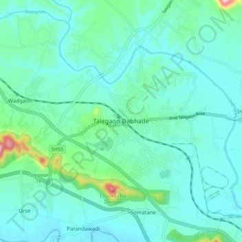
Nombre: Mapa topográfico Talegaon Dabhade, altitud, relieve.
Altitud media: 616 m
Altitud mínima: 567 m
Altitud máxima: 877 m
Gracias por apoyar a este sitio ❤️
Haz una donación
Haz una donación
Otros mapas topográficos
Haga clic en un mapa para ver su topografía, su altitud y su relieve.