
Mapa topográfico Tung Fort
Haga clic en el mapa para ver la altitud.
Acerca de este mapa
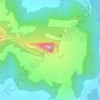
Nombre: Mapa topográfico Tung Fort, altitud, relieve.
Lugar: Tung Fort, Mawal, Pune District, Maharashtra, India (18.65804 73.45785 18.66097 73.46506)
Altitud media: 733 m
Altitud mínima: 604 m
Altitud máxima: 1.025 m
Otros mapas topográficos
Haga clic en un mapa para ver su topografía, su altitud y su relieve.
Lonavala
India > Maharashtra > Mawal
Adjacent to the Lohagad fort lies the visapur fort which is part of the Lohagad-Visapur fortification. Visapur Fort is larger and at a higher elevation than its twin- Lohagad. It was built during 1713-1720 CE by Balaji Vishwanath.
Altitud media: 613 m
Talegaon Dabhade
India > Maharashtra > Mawal
Talegaon Dabhade has an altitude of 672 meters from sea level (2200 Ft), and thus enjoys pleasant weather round the year. Situated on the laps of Sahyadri mountain ranges, during monsoon rains, Talegaon Dabhade witnesses heavy rainfall adding to its overall natural beauty. Indrayani River, which originates in…
Altitud media: 616 m
Shrivardhan Fort
India > Maharashtra > Mawal > Rajmachi village > Vanati Kakurwardi
Altitud media: 533 m
Visapur
India > Maharashtra > Mawal > Malavli
It is located in Pune district, 5 to 6 km from Malavli Railway station out of which 3 km is steep road. It has an elevation of 1084 meters above sea level. It is built on the same plateau as Lohagad.
Altitud media: 822 m
Talegaon Dabhade
India > Maharashtra > Mawal
Talegaon Dabhade has an altitude of 672 meters from sea level (2200 Ft), and thus enjoys pleasant weather round the year. Situated on the laps of Sahyadri mountain ranges, during monsoon rains, Talegaon Dabhade witnesses heavy rainfall adding to its overall natural beauty. Indrayani River, which originates in…
Altitud media: 616 m