
Haz una donación
Mapa topográfico Flattop Mountain
Haga clic en el mapa para ver la altitud.
Haz una donación
Flattop Mountain
It is usually reached by driving to the Glen Alps trailhead and following a 1.5-mile (2.4-km) trail, with an elevation gain of 1,280 feet (390 m) from the parking lot to the plateau. Off the plateau loop is a difficult trail to the peak. Since it is the most accessible mountain to Anchorage, Flattop is a very popular location for hiking, climbing, berry picking, paragliding, and backcountry skiing. Campouts are held on the summit at the summer and winter solstices.
Haz una donación
Acerca de este mapa
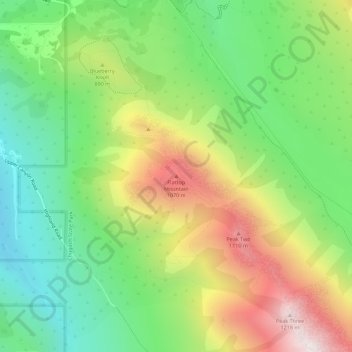
Nombre: Mapa topográfico Flattop Mountain, altitud, relieve.
Lugar: Flattop Mountain, Anchorage, Alaska, United States (61.08958 -149.66846 61.08968 -149.66836)
Altitud media: 735 m
Altitud mínima: 398 m
Altitud máxima: 1.237 m
Haz una donación
Otros mapas topográficos
Haga clic en un mapa para ver su topografía, su altitud y su relieve.
Haz una donación
Haz una donación