
Haz una donación
Mapa topográfico Chugiak
Haga clic en el mapa para ver la altitud.
Haz una donación
Acerca de este mapa
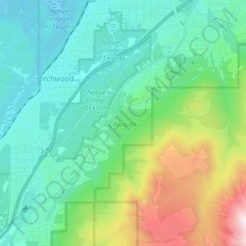
Nombre: Mapa topográfico Chugiak, altitud, relieve.
Lugar: Chugiak, Anchorage, Alaska, United States (61.34307 -149.55271 61.40472 -149.43473)
Altitud media: 295 m
Altitud mínima: 5 m
Altitud máxima: 1.250 m
Haz una donación
Otros mapas topográficos
Haga clic en un mapa para ver su topografía, su altitud y su relieve.
Alyeska
United States > Alaska > Anchorage > Girdwood
Alyeska has a subarctic climate (Köppen: Dfc), with short but mild summers and long, snowy winters. Snowfall is extremely heavy, owing to the Aleutian Low, with an average year getting 209 inches (530 cm) of snow at the base (elevation 250 feet above sea level) and an average exceeding 650 inches (17 meters)…
Altitud media: 256 m
Flattop Mountain
United States > Alaska > Anchorage
It is usually reached by driving to the Glen Alps trailhead and following a 1.5-mile (2.4-km) trail, with an elevation gain of 1,280 feet (390 m) from the parking lot to the plateau. Off the plateau loop is a difficult trail to the peak. Since it is the most accessible mountain to Anchorage, Flattop is a very…
Altitud media: 735 m
Haz una donación
Haz una donación