
Mapa topográfico Calape
Mapa interactivo
Haga clic en el mapa para ver la altitud.
Acerca de este mapa
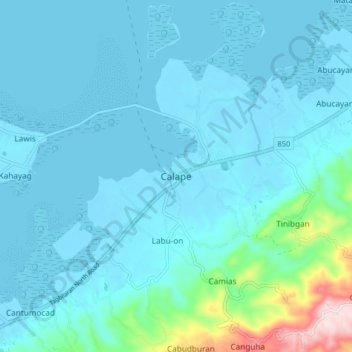
Nombre: Mapa topográfico Calape, altitud, relieve.
Lugar: Calape, Bohol, Central Visayas, 6328, Philippines (9.85051 123.83187 9.93051 123.91187)
Altitud media: 46 m
Altitud mínima: -6 m
Altitud máxima: 416 m
Most of the coastal area is a fairly level plain that gradually rises into rolling hills of coralline limestone. The highest point in Calape is Mount Candungao in the eastern portion of the town, with an elevation of 150 metres (500 ft) above sea level.
Otros mapas topográficos
Haga clic en un mapa para ver su topografía, su altitud y su relieve.
Cambacay
Philippines > Bohol > Batuan
Cambacay, Batuan, Bohol, Central Visayas, 6318, Philippines
Altitud media: 279 m
Rajah Sikatuna Protected Landscape
Philippines > Bohol > San Isidro
Rajah Sikatuna Protected Landscape, San Isidro, Bohol, Central Visayas, Philippines
Altitud media: 349 m
Duero
Philippines > Bohol > Duero
Duero, Bohol, Central Visayas, 6309, Philippines
Altitud media: 137 m
Catigbian
Philippines > Bohol > Catigbian
Catigbian, Bohol, Central Visayas, 6345, Philippines
Altitud media: 211 m
Tawala
Philippines > Bohol > Panglao > Tawala
Tawala, Panglao, Bohol, Central Visayas, 6340, Philippines
Altitud media: 14 m
Chocolate Hills
Philippines > Bohol > Buenos Aires
Chocolate Hills, Buenos Aires, Bohol, Central Visayas, 6318, Philippines
Altitud media: 315 m
Carmen
Philippines > Bohol > Carmen
Carmen, Bohol, Central Visayas, 6319, Philippines
Altitud media: 258 m
Sagbayan
Philippines > Bohol > Sagbayan
Sagbayan, Bohol, Central Visayas, 6331, Philippines
Altitud media: 248 m
Bınga
Philippines > Bohol > Tagbilaran
Bınga, Tagbilaran, Bohol, Central Visayas, 6344, Philippines
Altitud media: 79 m
Buenavista
Philippines > Bohol > Buenavista
Buenavista, Bohol, Central Visayas, 6333, Philippines
Altitud media: 14 m