
Haz una donación
Mapa topográfico Front Royal
Haga clic en el mapa para ver la altitud.
Haz una donación
Front Royal
Front Royal, located in Warren County, Virginia, sits at an elevation of approximately 570 feet (174 meters) above sea level. It lies in a diverse topographic region, with the town nestled at the confluence of the North and South Forks of the Shenandoah River, which contributes to its distinctive river valley landscape. The surrounding terrain is marked by rolling hills and moderate elevation changes, with some areas rising into the foothills of the Blue Ridge Mountains to the east. The area's proximity to these mountains results in a natural divide, with the town situated in a relatively low-lying area within the larger Shenandoah Valley.
Haz una donación
Acerca de este mapa
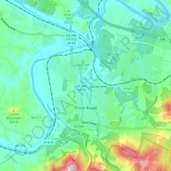
Nombre: Mapa topográfico Front Royal, altitud, relieve.
Lugar: Front Royal, Warren County, Virginia, United States (38.89164 -78.22068 38.96222 -78.14276)
Altitud media: 194 m
Altitud mínima: 132 m
Altitud máxima: 408 m
Haz una donación
Otros mapas topográficos
Haga clic en un mapa para ver su topografía, su altitud y su relieve.