
Gracias por apoyar a este sitio ❤️
Haz una donación
Haz una donación
Mapa topográfico Bentonville
Haga clic en el mapa para ver la altitud.
Gracias por apoyar a este sitio ❤️
Haz una donación
Haz una donación
Acerca de este mapa
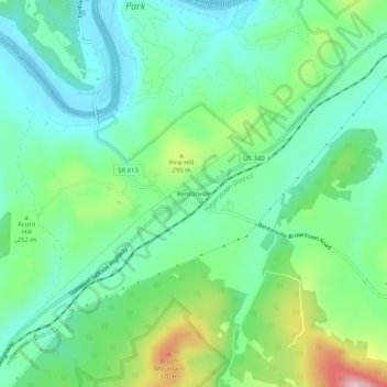
Nombre: Mapa topográfico Bentonville, altitud, relieve.
Lugar: Bentonville, Warren County, Virginia, 22610, United States (38.81142 -78.33682 38.85142 -78.29682)
Altitud media: 238 m
Altitud mínima: 160 m
Altitud máxima: 432 m
Gracias por apoyar a este sitio ❤️
Haz una donación
Haz una donación
Otros mapas topográficos
Haga clic en un mapa para ver su topografía, su altitud y su relieve.
Front Royal
United States > Virginia > Warren County
Front Royal, located in Warren County, Virginia, sits at an elevation of approximately 570 feet (174 meters) above sea level. It lies in a diverse topographic region, with the town nestled at the confluence of the North and South Forks of the Shenandoah River, which contributes to its distinctive river…
Altitud media: 194 m
Gracias por apoyar a este sitio ❤️
Haz una donación
Haz una donación