
Mapa topográfico Claremont
Mapa interactivo
Haga clic en el mapa para ver la altitud.
Acerca de este mapa
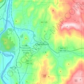
Nombre: Mapa topográfico Claremont, altitud, relieve.
Lugar: Claremont, Sullivan County, New Hampshire, United States (43.32202 -72.41617 43.42885 -72.26795)
Altitud media: 236 m
Altitud mínima: 83 m
Altitud máxima: 599 m
The city is in western Sullivan County and is bordered to the west by the Connecticut River, the boundary between New Hampshire and Vermont. According to the United States Census Bureau, the city has a total area of 44.1 square miles (114.1 km2), of which 43.2 square miles (111.8 km2) are land and 0.89 square miles (2.3 km2) are water, comprising 2.04% of the town. The Sugar River flows from east to west through the center of Claremont, descending 150 feet (46 m) in elevation through the downtown, and empties into the Connecticut. The highest point in the city is the summit of Green Mountain, at 2,018 feet (615 m) above sea level in the northeastern part of the city. Claremont lies fully within the Connecticut River watershed.
Otros mapas topográficos
Haga clic en un mapa para ver su topografía, su altitud y su relieve.
East Unity
United States > New Hampshire > Sullivan County > Unity
East Unity, Unity, Sullivan County, New Hampshire, United States
Altitud media: 399 m
Sunapee
United States > New Hampshire > Sullivan County
Sunapee, Sullivan County, New Hampshire, United States
Altitud media: 363 m
Croydon
United States > New Hampshire > Sullivan County
Croydon, Sullivan County, New Hampshire, United States
Altitud media: 372 m
Newport
United States > New Hampshire > Sullivan County
Newport, Sullivan County, New Hampshire, United States
Altitud media: 339 m
Ryder Corner
United States > New Hampshire > Sullivan County > Croydon
Ryder Corner, Croydon, Sullivan County, New Hampshire, 03754, United States
Altitud media: 352 m
Grantham
United States > New Hampshire > Sullivan County
Grantham, Sullivan County, New Hampshire, 03753, United States
Altitud media: 419 m
Unity
United States > New Hampshire > Sullivan County
Unity, Sullivan County, New Hampshire, United States
Altitud media: 369 m
Green Mountain
United States > New Hampshire > Sullivan County > Claremont
Green Mountain, Claremont, Sullivan County, New Hampshire, United States
Altitud media: 446 m
Goshen
United States > New Hampshire > Sullivan County > Goshen
Goshen, Sullivan County, New Hampshire, 03752, United States
Altitud media: 419 m
Eastman
United States > New Hampshire > Sullivan County > Grantham > Eastman
Eastman, Grantham, Sullivan County, New Hampshire, 03753, United States
Altitud media: 347 m
Acworth
United States > New Hampshire > Sullivan County
Acworth, Sullivan County, New Hampshire, 03601, United States
Altitud media: 380 m
Langdon
United States > New Hampshire > Sullivan County
Langdon, Sullivan County, New Hampshire, United States
Altitud media: 239 m
Mill Hollow
United States > New Hampshire > Sullivan County > Plainfield > Mill Hollow
Mill Hollow, Plainfield, Sullivan County, New Hampshire, 03770, United States
Altitud media: 313 m
Lempster
United States > New Hampshire > Sullivan County
Lempster, Sullivan County, New Hampshire, 03605, United States
Altitud media: 425 m
North Grantham
United States > New Hampshire > Sullivan County > Grantham > North Grantham
North Grantham, Grantham, Sullivan County, New Hampshire, 03753, United States
Altitud media: 386 m
Charlestown
United States > New Hampshire > Sullivan County
Charlestown, Sullivan County, New Hampshire, 03603, United States
Altitud media: 256 m
Plainfield
United States > New Hampshire > Sullivan County > Plainfield
Plainfield, Sullivan County, New Hampshire, United States
Altitud media: 267 m
Cornish
United States > New Hampshire > Sullivan County
Cornish, Sullivan County, New Hampshire, United States
Altitud media: 272 m