
Haz una donación
Mapa topográfico Alta
Haga clic en el mapa para ver la altitud.
Haz una donación
Alta
Alta experiences a high altitude humid continental climate (Köppen Dfb), which borders on a subalpine climate (Dfc), due to its high elevation. Due to its proximity to the Great Salt Lake, the town receives very heavy snows, averaging over 507 inches (12.9 m) per year. During the very wet season of 1982/1983, Alta received as much as 900 inches (23 m) of snow, leading to record flooding of Wasatch streams as the snow melted during May and June that year. Alta's total precipitation of 108.54 inches (2,756.9 mm) during 1983 is a record for a calendar year in any state of the Mountain West;.
Haz una donación
Acerca de este mapa
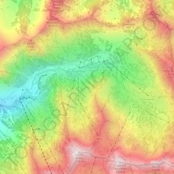
Nombre: Mapa topográfico Alta, altitud, relieve.
Lugar: Alta, Salt Lake County, Utah, United States (40.56441 -111.65273 40.60326 -111.59808)
Altitud media: 2.912 m
Altitud mínima: 2.437 m
Altitud máxima: 3.369 m
Haz una donación
Otros mapas topográficos
Haga clic en un mapa para ver su topografía, su altitud y su relieve.
Salt Lake City
United States > Utah > Salt Lake County > Salt Lake City
Salt Lake City has an area of 110.4 square miles (286 km2) and an average elevation of 4,327 feet (1,319 m) above sea level. The lowest point within the boundaries of the city is 4,210 feet (1,280 m) near the Jordan River and the Great Salt Lake, and the highest is Grandview Peak, at 9,410 feet (2,868 m).
Altitud media: 1.625 m
Haz una donación
Brighton
United States > Utah > Salt Lake County
Brighton has a high-altitude cold continental climate (Köppen Dsb/Dsc), with dry summers and very snowy winters.
Altitud media: 2.852 m
Haz una donación