
Haz una donación
Mapa topográfico Brighton
Haga clic en el mapa para ver la altitud.
Haz una donación
Brighton
Brighton has a high-altitude cold continental climate (Köppen Dsb/Dsc), with dry summers and very snowy winters.
Haz una donación
Acerca de este mapa
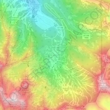
Nombre: Mapa topográfico Brighton, altitud, relieve.
Lugar: Brighton, Salt Lake County, Utah, United States (40.58182 -111.60331 40.62182 -111.56331)
Altitud media: 2.852 m
Altitud mínima: 2.487 m
Altitud máxima: 3.271 m
Haz una donación
Otros mapas topográficos
Haga clic en un mapa para ver su topografía, su altitud y su relieve.
Bluffdale
United States > Utah > Salt Lake County
Bluffdale has an area of 10.22 square miles (26.47 km2) and an average elevation of 4,436 feet (1,352 m) above sea level. Bluffdale is predominately located in Salt Lake County, though a portion of the city is in Utah County. Bluffdale shares city borders with Herriman to the west, Riverton to the north,…
Altitud media: 1.468 m
Alta
United States > Utah > Salt Lake County
Alta experiences a high altitude humid continental climate (Köppen Dfb), which borders on a subalpine climate (Dfc), due to its high elevation. Due to its proximity to the Great Salt Lake, the town receives very heavy snows, averaging over 507 inches (12.9 m) per year. During the very wet season of 1982/1983,…
Altitud media: 2.912 m
Haz una donación