
Haz una donación
Mapa topográfico Laguna Niguel
Haga clic en el mapa para ver la altitud.
Haz una donación
Laguna Niguel
Laguna Niguel consists of mostly hilly terrain, being located within the San Joaquin Hills. The average elevation is 400 feet (120 m); elevations range from near sea level to 936 feet (285 m) at the summit of Niguel Hill, in the southwest corner of the city. Neighboring cities are Aliso Viejo and Laguna Hills to the north, Mission Viejo and San Juan Capistrano to the east, and Laguna Beach and Dana Point to the south. On the west, it borders the significant unincorporated acreage of Aliso and Wood Canyons Wilderness Park.
Haz una donación
Acerca de este mapa
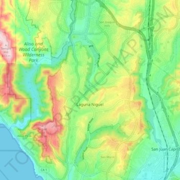
Nombre: Mapa topográfico Laguna Niguel, altitud, relieve.
Lugar: Laguna Niguel, Orange County, California, United States (33.48709 -117.74018 33.57141 -117.67251)
Altitud media: 110 m
Altitud mínima: 0 m
Altitud máxima: 308 m
Haz una donación
Otros mapas topográficos
Haga clic en un mapa para ver su topografía, su altitud y su relieve.
Haz una donación
Haz una donación
Haz una donación
Newport Beach
United States > California > Orange County > Newport Beach > Newport Beach
Newport Beach extends in elevation from sea level to the 1,161 ft (354 m) summit of Signal Peak in the San Joaquin Hills, but the official elevation is 25 ft (7.6 m) above sea level at a location of 33°37′0″N 117°53′51″W / 33.61667°N 117.89750°W / 33.61667; -117.89750 (33.616671, −117.897604).
Altitud media: 9 m
Haz una donación
Haz una donación
Haz una donación
Haz una donación
Haz una donación
Haz una donación
Haz una donación