
Haz una donación
Mapa topográfico Harwinton
Haga clic en el mapa para ver la altitud.
Haz una donación
Acerca de este mapa
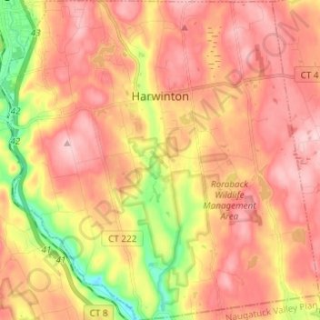
Nombre: Mapa topográfico Harwinton, altitud, relieve.
Altitud media: 252 m
Altitud mínima: 117 m
Altitud máxima: 341 m
Haz una donación
Otros mapas topográficos
Haga clic en un mapa para ver su topografía, su altitud y su relieve.
Nelsons Corner
United States > Connecticut > Northwest Hills Planning Region > Winchester
Altitud media: 275 m
Bartholomew Hill
United States > Connecticut > Northwest Hills Planning Region > Goshen
Altitud media: 426 m
Bakerville
United States > Connecticut > Northwest Hills Planning Region > New Hartford
Altitud media: 244 m
Haz una donación
Haystack Mountain
United States > Connecticut > Northwest Hills Planning Region > Norfolk
Altitud media: 385 m
Marble Dale
United States > Connecticut > Northwest Hills Planning Region > Washington
Altitud media: 249 m
Washington Depot
United States > Connecticut > Northwest Hills Planning Region > Washington
Altitud media: 231 m
Pleasant Valley
United States > Connecticut > Northwest Hills Planning Region > Barkhamsted
Altitud media: 192 m
Haz una donación
Drakeville
United States > Connecticut > Northwest Hills Planning Region > Torrington
Altitud media: 309 m
Apple Hill
United States > Connecticut > Northwest Hills Planning Region > Morris
Altitud media: 297 m
Northfield
United States > Connecticut > Northwest Hills Planning Region > Litchfield
Altitud media: 259 m
Nepaug
United States > Connecticut > Northwest Hills Planning Region > New Hartford
Altitud media: 222 m
Haz una donación
Lakeville
United States > Connecticut > Northwest Hills Planning Region > Salisbury
Altitud media: 259 m
East Morris
United States > Connecticut > Northwest Hills Planning Region > Morris
Altitud media: 294 m
Wangum Village
United States > Connecticut > Northwest Hills Planning Region > Canaan
Altitud media: 235 m
Bear Mountain
United States > Connecticut > Northwest Hills Planning Region > Salisbury
Bear Mountain is a peak of the southern Taconic Mountains in Salisbury, Connecticut. At 2,316 feet (706 m) (note, per references 1 and 3, there is disagreement about the precise elevation), Bear Mountain is the highest mountain that lies wholly within Connecticut. However, it is not the state highpoint: in the…
Altitud media: 544 m
Haz una donación
The Matterhorn
United States > Connecticut > Northwest Hills Planning Region > Canaan
Altitud media: 462 m
Northfield
United States > Connecticut > Northwest Hills Planning Region > Litchfield
Altitud media: 259 m
The Matterhorn
United States > Connecticut > Northwest Hills Planning Region > Canaan
Altitud media: 462 m
Bradford Mountain
United States > Connecticut > Northwest Hills Planning Region > Canaan
Altitud media: 470 m
Haz una donación
Bulls Bridge
United States > Connecticut > Northwest Hills Planning Region > Kent
Altitud media: 178 m
Bear Mountain
United States > Connecticut > Northwest Hills Planning Region > Salisbury
Bear Mountain is a peak of the southern Taconic Mountains in Salisbury, Connecticut. At 2,316 feet (706 m) (note, per references 1 and 3, there is disagreement about the precise elevation), Bear Mountain is the highest mountain that lies wholly within Connecticut. However, it is not the state highpoint: in the…
Altitud media: 544 m
Town Hill
United States > Connecticut > Northwest Hills Planning Region > New Hartford
Altitud media: 255 m
Torringford
United States > Connecticut > Northwest Hills Planning Region > Torrington
Altitud media: 301 m
Haz una donación
Bear Mountain
United States > Connecticut > Northwest Hills Planning Region > Salisbury
Bear Mountain is a peak of the southern Taconic Mountains in Salisbury, Connecticut. At 2,316 feet (706 m) (note, per references 1 and 3, there is disagreement about the precise elevation), Bear Mountain is the highest mountain that lies wholly within Connecticut. However, it is not the state highpoint: in the…
Altitud media: 544 m
Northfield
United States > Connecticut > Northwest Hills Planning Region > Litchfield
Altitud media: 259 m
Grand Staircase
United States > Connecticut > Northwest Hills Planning Region > Kent
Altitud media: 205 m
Milton Hill
United States > Connecticut > Northwest Hills Planning Region > Goshen
Altitud media: 368 m
Haz una donación
Lime Rock
United States > Connecticut > Northwest Hills Planning Region > Salisbury
Altitud media: 238 m
Panorama Hill
United States > Connecticut > Northwest Hills Planning Region > Colebrook
Altitud media: 379 m
Apple Hill
United States > Connecticut > Northwest Hills Planning Region > Morris
Altitud media: 297 m
Canaan Valley
United States > Connecticut > Northwest Hills Planning Region > North Canaan
Altitud media: 293 m
Haz una donación
Canaan Valley
United States > Connecticut > Northwest Hills Planning Region > North Canaan
Altitud media: 293 m
Burrville
United States > Connecticut > Northwest Hills Planning Region > Torrington
Altitud media: 292 m
Haz una donación