
Mapa topográfico Sugarloaf Mountain
Mapa interactivo
Haga clic en el mapa para ver la altitud.
Acerca de este mapa
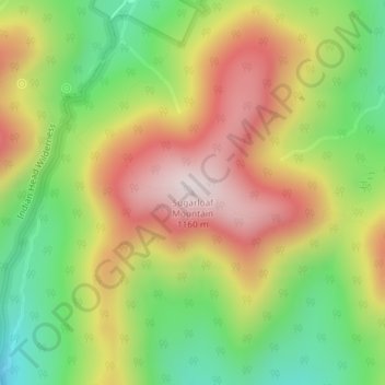
Nombre: Mapa topográfico Sugarloaf Mountain, altitud, relieve.
Altitud media: 846 m
Altitud mínima: 567 m
Altitud máxima: 1.145 m
Otros mapas topográficos
Haga clic en un mapa para ver su topografía, su altitud y su relieve.
Village of Tannersville
United States > New York > Greene County > Town of Hunter
Village of Tannersville, Town of Hunter, Greene County, New York, United States
Altitud media: 613 m