
Mapa topográfico Village of Tannersville
Mapa interactivo
Haga clic en el mapa para ver la altitud.
Acerca de este mapa
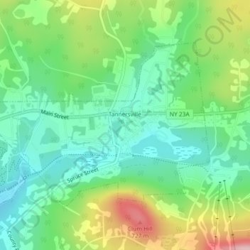
Nombre: Mapa topográfico Village of Tannersville, altitud, relieve.
Altitud media: 613 m
Altitud mínima: 547 m
Altitud máxima: 742 m
Tannersville is located in southern Greene County at 42°11′37″N 74°8′20″W / 42.19361°N 74.13889°W / 42.19361; -74.13889 (42.193619, -74.139011), in the northern part of the town of Hunter. It is situated at an elevation of 1,900 feet (580 m) in the Catskill Mountains just west of the height of land on New York State Route 23A: Sawmill Creek flows southwest through the center of the village into Gooseberry Creek and thence into Schoharie Creek, a north-flowing tributary of the Mohawk River, while just 2 miles (3 km) to the east, at Haines Falls, Kaaterskill Creek drops east into Kaaterskill Clove and thence into the Hudson River valley.
Otros mapas topográficos
Haga clic en un mapa para ver su topografía, su altitud y su relieve.
Sugarloaf Mountain
United States > New York > Greene County > Town of Hunter
Sugarloaf Mountain, Town of Hunter, Greene County, New York, United States
Altitud media: 846 m