
Haz una donación
Mapa topográfico Santa Cruz Mountains
Haga clic en el mapa para ver la altitud.
Haz una donación
Santa Cruz Mountains
The Santa Cruz Mountains are a region of great biological diversity, encompassing cool, moist coastal ecosystems as well as warm, dry chaparral. Much of the area in the Santa Cruz mountains is temperate rainforest. In valleys and moist ocean-facing slopes some of the southernmost coast redwoods grow, along with coast Douglas-fir. Coast live oak, Pacific madrone, Pacific wax myrtle, big leaf maple, California bay laurel, and California black oak also occur in the Santa Cruz Mountains. There do exist several small and isolated stands of old-growth forest, most notably at Henry Cowell Redwoods and Portola Redwoods State Parks and one sizeable old-growth redwood forest at Big Basin. At higher elevations and on sunny south slopes a more drought-resistant chaparral vegetation dominates: manzanita, California scrub oak, chamise, and chaparral pea. Spring wildflowers are also widespread throughout the range.
Haz una donación
Acerca de este mapa
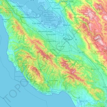
Nombre: Mapa topográfico Santa Cruz Mountains, altitud, relieve.
Altitud media: 230 m
Altitud mínima: -4 m
Altitud máxima: 1.270 m
Haz una donación
Otros mapas topográficos
Haga clic en un mapa para ver su topografía, su altitud y su relieve.
San Jose
United States > California > Santa Clara County
San Jose, located in Santa Clara County, California, features a diverse topography characterized by a mix of low-lying plains and rolling hills. The city sits at an average elevation of approximately 82 feet (25 meters) above sea level, with the surrounding terrain including the foothills of the Santa Cruz…
Altitud media: 265 m
Palo Alto
United States > California > Santa Clara County
The official elevation is 30 feet (9 m) above sea level, but the city boundaries reach well into the northern section of the Santa Cruz Mountains.
Altitud media: 187 m
Haz una donación
Sunnyvale
United States > California > Santa Clara County
According to the United States Census Bureau, the city has a total area of 22.7 sq mi (58.8 km2), of which, 22.0 sq mi (56.9 km2) of it is land and 0.69 sq mi (1.8 km2) of it (3.09%) is water. Its elevation is 130 feet above sea level.
Altitud media: 24 m
Santa Clara
United States > California > Santa Clara County
In 1905, the first public high-altitude flights by humans were made over Santa Clara in gliders designed by John J. Montgomery. The semiconductor industry, which sprouted around 1960, changed the city and surrounding Valley of Heart's Delight; little of its agricultural past remains.
Altitud media: 18 m
Haz una donación
Milpitas
United States > California > Santa Clara County
The median elevation of Milpitas is 19 feet (6 m). At Piedmont Road, Evans Road, and North Park Victoria Avenue, the elevation is generally about 100 feet (30 m), while the western area is almost at sea level. The highest point in Milpitas is a 1,289-foot (393 m) peak in the southeastern foothills.
Altitud media: 46 m
Haz una donación
Coyote
United States > California > Santa Clara County
Due to the moderating influence of the Pacific Ocean, Coyote enjoys a mild, Mediterranean climate. Temperatures range from an average midsummer maximum of 32.3°C (90.2°F) to an average midwinter low of 0.9 °C (33.6 °F). Average annual precipitation is 480 mm (18.9 in), and the summer months are typically…
Altitud media: 131 m
Haz una donación
Ed R. Levin County Park
United States > California > Santa Clara County > Milpitas
Altitud media: 301 m
Haz una donación
Gilroy
United States > California > Santa Clara County
Gilroy is approximately 16 miles (26 km) south of San Jose, California (Bailey Avenue (37.206770, -121.729150) to Monterey/Day Road (37.038210, -121.584480)) on U.S. Route 101 and 19 miles (31 km) inland from the Pacific Coast. Despite its apparent close proximity to San Jose, it is important to note that…
Altitud media: 107 m
Morgan Hill
United States > California > Santa Clara County
Morgan Hill is approximately 24 mi (39 km) south of downtown San Jose, 13 mi (21 km) north of Gilroy, and 15 mi (24 km) inland from the Pacific coast. Lying in a roughly 4-mile-wide (6 km) southern extension of the Santa Clara Valley, it is bounded by the Santa Cruz Mountains to the west and the Diablo Range…
Altitud media: 153 m
Haz una donación
Lexington Reservoir County Park
United States > California > Santa Clara County > Los Gatos
The reservoir is in the foothills of the Santa Cruz Mountains, at an elevation of 645 feet (197 m).
Altitud media: 330 m
Haz una donación
Upper Los Gatos Creek Watershed Reserve
United States > California > Santa Clara County > Saratoga
Altitud media: 399 m
Mount Umunhum
United States > California > Santa Clara County
The mountain is also the site of the Bay Area NEXRAD weather radar. The high elevation is necessary for line of sight in the region's varied terrain, but it also limits the ability to detect storms with bases lower in the atmosphere.
Altitud media: 770 m
Haz una donación
Palo Alto
United States > California > Santa Clara County
The official elevation is 30 feet (9 m) above sea level, but the city boundaries reach well into the peninsula hills.
Altitud media: 187 m
Sunnyvale
United States > California > Santa Clara County
According to the United States Census Bureau, the city has a total area of 22.7 sq mi (58.8 km2), of which, 22.0 sq mi (56.9 km2) of it is land and 0.69 sq mi (1.8 km2) of it (3.09%) is water. Its elevation is 130 feet above sea level.
Altitud media: 24 m
Haz una donación
Haz una donación
Palo Alto
United States > California > Santa Clara County
The official elevation is 30 feet (9 m) above sea level, but the city boundaries reach well into the peninsula hills.
Altitud media: 187 m
Haz una donación
Morgan Hill
United States > California > Santa Clara County
Morgan Hill is approximately 24 mi (39 km) south of downtown San Jose, 13 mi (21 km) north of Gilroy, and 15 mi (24 km) inland from the Pacific coast. Lying in a roughly 4-mile-wide (6 km) southern extension of the Santa Clara Valley, it is bounded by the Santa Cruz Mountains to the west and the Diablo Range…
Altitud media: 153 m
Morgan Hill
United States > California > Santa Clara County > Morgan Hill
Morgan Hill is approximately 39 km (24 mi) south of downtown San Jose, 21 km (13 mi) north of Gilroy, and 24 km (15 mi) inland from the Pacific coast. Lying in a roughly 6 km-wide (4-mi-wide) southern extension of the Santa Clara Valley, it is bounded by the Santa Cruz Mountains to the west and the Diablo…
Altitud media: 145 m
Haz una donación
Los Altos Hills
United States > California > Santa Clara County > Los Altos Hills > Los Altos Hills
Altitud media: 94 m
Haz una donación
Morgan Hill
United States > California > Santa Clara County
Morgan Hill is approximately 24 mi (39 km) south of downtown San Jose, 13 mi (21 km) north of Gilroy, and 15 mi (24 km) inland from the Pacific coast. Lying in a roughly 4-mile-wide (6 km) southern extension of the Santa Clara Valley, it is bounded by the Santa Cruz Mountains to the west and the Diablo Range…
Altitud media: 153 m
Pacheco Pass
United States > California > Santa Clara County
Pacheco Pass, elevation 1,368 ft (417 m), is a low mountain pass located in the Diablo Range in southeastern Santa Clara County, California. It is the main route through the hills separating the Santa Clara Valley and the Central Valley.
Altitud media: 425 m
Haz una donación
Haz una donación
Santa Clara
United States > California > Santa Clara County
In 1905, the first public high-altitude flights by humans were made over Santa Clara in gliders designed by John J. Montgomery. The semiconductor industry, which sprouted around 1960, changed the city and surrounding Valley of Heart's Delight; little of its agricultural past remains.
Altitud media: 18 m
Haz una donación
Sunnyvale
United States > California > Santa Clara County
According to the United States Census Bureau, the city has a total area of 22.7 sq mi (58.8 km2), of which, 22.0 sq mi (56.9 km2) of it is land and 0.69 sq mi (1.8 km2) of it (3.09%) is water. Its elevation is 130 feet above sea level.
Altitud media: 24 m
Gilroy
United States > California > Santa Clara County
Due to the moderating influence of the Pacific Ocean, Gilroy experiences a warm Mediterranean climate (Köppen Csb, bordering on Csa). Temperatures range from an average midsummer maximum of 90.1 °F (32.3 °C) to an average midwinter low of 33.6 °F (0.9 °C). Average annual precipitation is 18.9 inches (480…
Altitud media: 107 m
Haz una donación
Haz una donación
Santa Clara
United States > California > Santa Clara County
In 1905, the first public high-altitude flights by humans were made over Santa Clara in gliders designed by John J. Montgomery. The semiconductor industry, which sprouted around 1960, changed the city and surrounding Valley of Heart's Delight; little of its agricultural past remains.
Altitud media: 18 m
Palo Alto
United States > California > Santa Clara County
The official elevation is 30 feet (9 m) above sea level, but the city boundaries reach well into the northern section of the Santa Cruz Mountains.
Altitud media: 187 m
Palo Alto
United States > California > Santa Clara County
The official elevation is 30 feet (9 m) above sea level, but the city boundaries reach well into the northern section of the Santa Cruz Mountains.
Altitud media: 187 m
Haz una donación
Haz una donación
Santa Clara
United States > California > Santa Clara County
In 1905, the first public high-altitude flights by humans were made over Santa Clara in gliders designed by John J. Montgomery. The semiconductor industry, which sprouted around 1960, changed the city and surrounding Valley of Heart's Delight; little of its agricultural past remains.
Altitud media: 18 m
Haz una donación
Haz una donación
Haz una donación
Gilroy
United States > California > Santa Clara County
Gilroy is approximately 16 miles (26 km) south of San Jose, California (Bailey Avenue (37.206770, -121.729150) to Monterey/Day Road (37.038210, -121.584480)) on U.S. Route 101 and 19 miles (31 km) inland from the Pacific Coast. Despite its apparent close proximity to San Jose, it is important to note that…
Altitud media: 107 m
Haz una donación
Palo Alto
United States > California > Santa Clara County
The official elevation is 30 feet (9 m) above sea level, but the city boundaries reach well into the peninsula hills.
Altitud media: 187 m
Haz una donación