
Haz una donación
Mapa topográfico Salisbury
Haga clic en el mapa para ver la altitud.
Haz una donación
Salisbury
According to the U.S. Census Bureau, the township has a total area of 11.3 square miles (29.2 km2), of which 11.2 square miles (28.9 km2) are land and 0.1 square miles (0.3 km2), or 0.87%, are water.[1] It is drained by the Lehigh River, which separates it from Bethlehem and the east side of Allentown, and borders Upper Saucon Township on South Mountain. Elevations range from approximately 220 feet (67 m) above sea level on the river to 1,030 feet (310 m) in Big Rock County Park.
Haz una donación
Acerca de este mapa
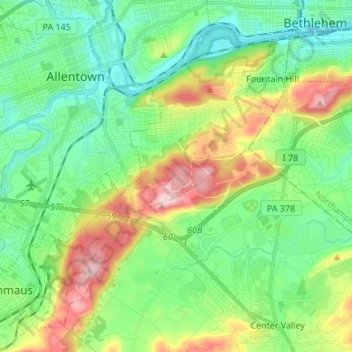
Nombre: Mapa topográfico Salisbury, altitud, relieve.
Lugar: Salisbury, Lehigh County, Pennsylvania, United States (40.52913 -75.53005 40.61699 -75.39429)
Altitud media: 143 m
Altitud mínima: 63 m
Altitud máxima: 316 m
Haz una donación
Otros mapas topográficos
Haga clic en un mapa para ver su topografía, su altitud y su relieve.
East Texas
United States > Pennsylvania > Lehigh County > Lower Macungie Township
Altitud media: 126 m
Centreville
United States > Pennsylvania > Lehigh County > Lower Macungie Township
Altitud media: 144 m
Haz una donación
Leather Corner Post
United States > Pennsylvania > Lehigh County > Lowhill Township
Altitud media: 178 m
South Mountain
United States > Pennsylvania > Lehigh County > Upper Saucon
Unlike Blue Mountain to its north, South Mountain does not follow a straight geographic line. The mountain ranges in elevation between 500 and 1,300 feet (150 and 400 m) above sea level. The ridge is made of metamorphic rocks and gneiss, which date to the Precambrian era and range from about 570 million to…
Altitud media: 153 m
Haz una donación
Vera Cruz Station
United States > Pennsylvania > Lehigh County > Upper Milford Township
Altitud media: 199 m
South Mountain
United States > Pennsylvania > Lehigh County > Upper Saucon
Unlike Blue Mountain to its north, South Mountain does not follow a straight geographic line. The mountain ranges in elevation between 500 and 1,300 feet (150 and 400 m) above sea level. The ridge is made of metamorphic rocks and gneiss, which date to the Precambrian era and range from about 570 million to…
Altitud media: 153 m
Haz una donación
Trexlertown
United States > Pennsylvania > Lehigh County > Upper Macungie Township
Trexlertown is located southwest of the center of Lehigh County along the southeastern edge of Upper Macungie Township at an altitude of 397 feet (121 m). It is bordered to the southwest by Breinigsville and to the southeast by Lower Macungie Township. U.S. Route 222 forms the northern edge of the community;…
Altitud media: 127 m
North Fogelsville
United States > Pennsylvania > Lehigh County > Upper Macungie Township > Fogelsville
Altitud media: 165 m
Kernsville
United States > Pennsylvania > Lehigh County > North Whitehall Township
Altitud media: 147 m
Haz una donación
Leather Corner Post
United States > Pennsylvania > Lehigh County > Lowhill Township
Altitud media: 178 m
Haz una donación
Weilersville
United States > Pennsylvania > Lehigh County > Lower Macungie Township
Altitud media: 126 m
Fogelsville
United States > Pennsylvania > Lehigh County > Upper Macungie Township
Altitud media: 155 m
Wescosville
United States > Pennsylvania > Lehigh County > Lower Macungie Township
Altitud media: 128 m
Haz una donación
Cherry Hill
United States > Pennsylvania > Lehigh County > Upper Macungie Township
Altitud media: 146 m
Weidasville
United States > Pennsylvania > Lehigh County > Lowhill Township > Weidasville
Altitud media: 170 m
Crackersport
United States > Pennsylvania > Lehigh County > South Whitehall Township
Altitud media: 138 m
Haz una donación