
Haz una donación
Mapa topográfico Monroe
Haga clic en el mapa para ver la altitud.
Haz una donación
Monroe
According to the United States Census Bureau, the city has a total area of 10.18 square miles (26.37 km2), of which 9.17 square miles (23.75 km2) is land and 1.01 square miles (2.62 km2) (9.92%) is water. Monroe sits at the lowest elevation in state of Michigan, which is the shores of Lake Erie at 571 feet (174 meters). The average elevation of the city of Monroe is 594 feet (181 meters). The Port of Monroe is the only Michigan port on Lake Erie, and Sterling State Park is the only of Michigan's 103 state parks located on or near Lake Erie. The River Raisin and Sandy Creek travel through Monroe; they are non-navigable because of the several dams and other obstructions.
Haz una donación
Acerca de este mapa
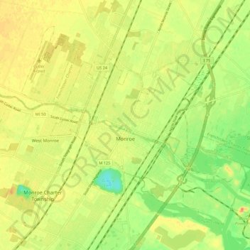
Nombre: Mapa topográfico Monroe, altitud, relieve.
Lugar: Monroe, Monroe County, Michigan, United States (41.88681 -83.44217 41.95087 -83.33374)
Altitud media: 182 m
Altitud mínima: 157 m
Altitud máxima: 200 m
Haz una donación
Otros mapas topográficos
Haga clic en un mapa para ver su topografía, su altitud y su relieve.
River Raisin
United States > Michigan > Monroe County > Raisinville Township > Grape
Altitud media: 192 m
Haz una donación