
Haz una donación
Mapa topográfico Gallipolis
Haga clic en el mapa para ver la altitud.
Haz una donación
Gallipolis
Winters are cold, with an average January temperature of 34.3 °F (1.3 °C). Snowfall is generally very light, with a mean average snowfall of 10.9 inches (280 mm). The village does not experience by lake-effect snow, although the village's weather can be influenced by the Great Lakes and regional topography. On average, there are 109 nights per year when the temperature drops to or below freezing, and only 14 days when the temperature fails to rise above freezing. Summers are hot and humid, with an average July temperature of 78.6 °F (25.9 °C). There are an average of 39 days per year with highs at or above 90 °F (32 °C).
Haz una donación
Acerca de este mapa
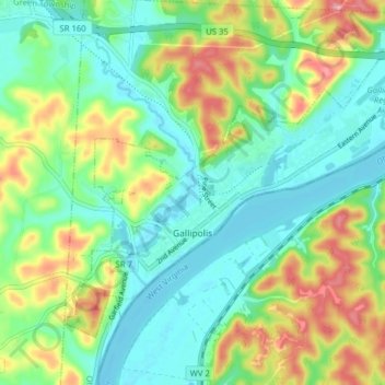
Nombre: Mapa topográfico Gallipolis, altitud, relieve.
Lugar: Gallipolis, Gallia County, Ohio, United States (38.79311 -82.22809 38.83919 -82.14937)
Altitud media: 203 m
Altitud mínima: 165 m
Altitud máxima: 278 m
Haz una donación
Otros mapas topográficos
Haga clic en un mapa para ver su topografía, su altitud y su relieve.