
Gracias por apoyar a este sitio ❤️
Haz una donación
Haz una donación
Mapa topográfico Patriot
Haga clic en el mapa para ver la altitud.
Gracias por apoyar a este sitio ❤️
Haz una donación
Haz una donación
Acerca de este mapa
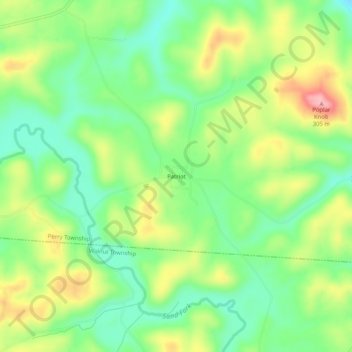
Nombre: Mapa topográfico Patriot, altitud, relieve.
Altitud media: 225 m
Altitud mínima: 169 m
Altitud máxima: 308 m
Gracias por apoyar a este sitio ❤️
Haz una donación
Haz una donación
Otros mapas topográficos
Haga clic en un mapa para ver su topografía, su altitud y su relieve.
Gallipolis
United States > Ohio > Gallia County
Winters are cold, with an average January temperature of 34.3 °F (1.3 °C). Snowfall is generally very light, with a mean average snowfall of 10.9 inches (280 mm). The village does not experience by lake-effect snow, although the village's weather can be influenced by the Great Lakes and regional topography.…
Altitud media: 203 m
Gracias por apoyar a este sitio ❤️
Haz una donación
Haz una donación