
Gracias por apoyar a este sitio ❤️
Haz una donación
Haz una donación
Mapa topográfico Green Forest
Haga clic en el mapa para ver la altitud.
Gracias por apoyar a este sitio ❤️
Haz una donación
Haz una donación
Acerca de este mapa
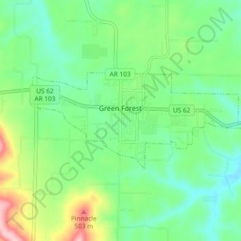
Nombre: Mapa topográfico Green Forest, altitud, relieve.
Lugar: Green Forest, Carroll County, Arkansas, 72638, United States (36.32230 -93.45984 36.34296 -93.39579)
Altitud media: 413 m
Altitud mínima: 357 m
Altitud máxima: 540 m
Gracias por apoyar a este sitio ❤️
Haz una donación
Haz una donación
Otros mapas topográficos
Haga clic en un mapa para ver su topografía, su altitud y su relieve.
Gracias por apoyar a este sitio ❤️
Haz una donación
Haz una donación
Eureka Springs
United States > Arkansas > Carroll County > Eureka Springs
It is a tourist destination for its unique character as a Victorian resort village. The city has steep winding streets filled with Victorian-style cottages and manors. The historic commercial downtown of the city has an extensive streetscape of well-preserved Victorian buildings. The buildings are primarily…
Altitud media: 417 m