
Haz una donación
Mapa topográfico Osage
Haga clic en el mapa para ver la altitud.
Haz una donación
Acerca de este mapa
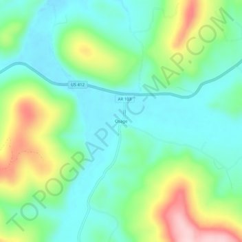
Nombre: Mapa topográfico Osage, altitud, relieve.
Lugar: Osage, Carroll County, Arkansas, United States (36.16257 -93.42463 36.20257 -93.38463)
Altitud media: 465 m
Altitud mínima: 390 m
Altitud máxima: 632 m
Haz una donación
Otros mapas topográficos
Haga clic en un mapa para ver su topografía, su altitud y su relieve.
Eureka Springs
United States > Arkansas > Carroll County
It is a tourist destination for its unique character as a Victorian resort, which first attracted visitors to use its then believed healing springs. The city has steep winding streets filled with Victorian-style cottages and manors. The historic commercial downtown of the city has an extensive streetscape of…
Altitud media: 411 m
Haz una donación
Eureka Springs
United States > Arkansas > Carroll County
It is a tourist destination for its unique character as a Victorian resort, which first attracted visitors to use its then believed healing springs. The city has steep winding streets filled with Victorian-style cottages and manors. The historic commercial downtown of the city has an extensive streetscape of…
Altitud media: 411 m
Eureka Springs
United States > Arkansas > Carroll County
It is a tourist destination for its unique character as a Victorian resort, which first attracted visitors to use its then-believed healing springs. The city has steep, winding streets filled with Victorian-style cottages and manors. The historic commercial downtown of the city has an extensive streetscape of…
Altitud media: 411 m
Eureka Springs
United States > Arkansas > Carroll County
It is a tourist destination for its unique character as a Victorian resort, which first attracted visitors to use its then believed healing springs. The city has steep winding streets filled with Victorian-style cottages and manors. The historic commercial downtown of the city has an extensive streetscape of…
Altitud media: 411 m
Haz una donación