
Haz una donación
Mapa topográfico Sutton
Haga clic en el mapa para ver la altitud.
Haz una donación
Sutton
The highest point in Sutton is the summit of Mount Hor in the northern corner of town, with an elevation of 2,656 feet (809.5 m) above sea level. The modest elevation of this town gives it a slightly cooler and wetter climate than nearby towns such as St. Johnsbury. Annual snowfall averages well over 100 inches per year at the weather station in the center of town.
Haz una donación
Acerca de este mapa
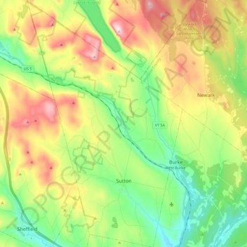
Nombre: Mapa topográfico Sutton, altitud, relieve.
Lugar: Sutton, Caledonia County, Vermont, 05867, United States (44.59017 -72.11436 44.74981 -71.97325)
Altitud media: 459 m
Altitud mínima: 224 m
Altitud máxima: 830 m
Haz una donación
Otros mapas topográficos
Haga clic en un mapa para ver su topografía, su altitud y su relieve.
Haz una donación
East Saint Johnsbury
United States > Vermont > Caledonia County > Saint Johnsbury
Altitud media: 311 m
Haz una donación
Haz una donación