
Haz una donación
Mapa topográfico Passumpsic
Haga clic en el mapa para ver la altitud.
Haz una donación
Acerca de este mapa
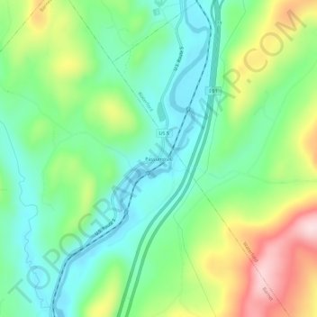
Nombre: Mapa topográfico Passumpsic, altitud, relieve.
Altitud media: 254 m
Altitud mínima: 148 m
Altitud máxima: 462 m
Haz una donación
Otros mapas topográficos
Haga clic en un mapa para ver su topografía, su altitud y su relieve.
Haz una donación
Lyndon
United States > Vermont > Caledonia County
The highest point in Lyndon is Diamond Hill in the southwest, with an elevation of slightly greater than 1,640 feet (500 m).
Altitud media: 317 m
Walden
United States > Vermont > Caledonia County
The highest point in Walden is the summit of Stannard Mountain, near the town's northern border, with an elevation of over 2,579 feet (786 m) above sea level.
Altitud media: 511 m
Haz una donación
Sutton
United States > Vermont > Caledonia County
The highest point in Sutton is the summit of Mount Hor in the northern corner of town, with an elevation of 2,656 feet (809.5 m) above sea level. The modest elevation of this town gives it a slightly cooler and wetter climate than nearby towns such as St. Johnsbury. Annual snowfall averages well over 100…
Altitud media: 459 m
Wheelock
United States > Vermont > Caledonia County
The highest point in town is Wheelock Mountain, with an elevation of 2,782 feet (848 m).
Altitud media: 412 m