
Haz una donación
Mapa topográfico Boones Mill
Haga clic en el mapa para ver la altitud.
Haz una donación
Boones Mill
According to the United States Census Bureau, the town has a total area of 0.73 square miles (1.9 km2), all of it land. The town is in the valley of Maggodee Creek, a southeast-flowing tributary of the Blackwater River, part of the Roanoke River watershed. Murray Knob, elevation 2,286 feet (697 m), rises 2 miles (3 km) to the north on the crest of the Blue Ridge, and the eastern end of Cahas Mountain, at 2,992 feet (912 m), is 2 miles to the west.
Haz una donación
Acerca de este mapa
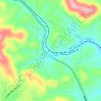
Nombre: Mapa topográfico Boones Mill, altitud, relieve.
Lugar: Boones Mill, Franklin County, Virginia, United States (37.10687 -79.95893 37.12478 -79.94342)
Altitud media: 390 m
Altitud mínima: 326 m
Altitud máxima: 506 m
Haz una donación
Otros mapas topográficos
Haga clic en un mapa para ver su topografía, su altitud y su relieve.