
Haz una donación
Mapa topográfico Callaway
Haga clic en el mapa para ver la altitud.
Haz una donación
Acerca de este mapa
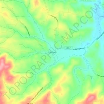
Nombre: Mapa topográfico Callaway, altitud, relieve.
Lugar: Callaway, Franklin County, Virginia, 24067, United States (36.99153 -80.06948 37.03153 -80.02948)
Altitud media: 398 m
Altitud mínima: 345 m
Altitud máxima: 477 m
Haz una donación
Otros mapas topográficos
Haga clic en un mapa para ver su topografía, su altitud y su relieve.
Haz una donación
Boones Mill
United States > Virginia > Franklin County
According to the United States Census Bureau, the town has a total area of 0.73 square miles (1.9 km2), all of it land. The town is in the valley of Maggodee Creek, a southeast-flowing tributary of the Blackwater River, part of the Roanoke River watershed. Murray Knob, elevation 2,286 feet (697 m), rises 2…
Altitud media: 390 m
Haz una donación