
Haz una donación
Mapa topográfico Akron
Haga clic en el mapa para ver la altitud.
Haz una donación
Akron
Akron is situated within the Glaciated Allegheny Plateau, creating a rolling landscape with variable elevations. The city, which lies around 40 miles south of Lake Erie, has an average elevation of approximately 960 feet above sea level, though elevations range from about 700 feet along the Cuyahoga River Valley to nearly 1,200 feet on higher points within the city. This varied terrain includes gentle hills, river valleys, and the Ohio and Erie Canal, which flows through Akron and effectively divides the city's east and west. These features highlight Akron's topographic diversity within Northeast Ohio, contributing to its unique geological character as part of the Great Lakes region.
Haz una donación
Acerca de este mapa
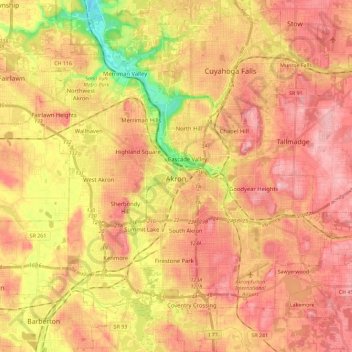
Nombre: Mapa topográfico Akron, altitud, relieve.
Lugar: Akron, Summit County, Ohio, United States (40.99766 -81.62101 41.17106 -81.40494)
Altitud media: 315 m
Altitud mínima: 216 m
Altitud máxima: 377 m
Haz una donación
Otros mapas topográficos
Haga clic en un mapa para ver su topografía, su altitud y su relieve.
Haz una donación
Haz una donación