
Haz una donación
Mapa topográfico Copley
Haga clic en el mapa para ver la altitud.
Haz una donación
Acerca de este mapa
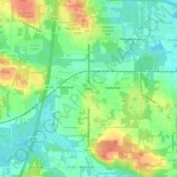
Nombre: Mapa topográfico Copley, altitud, relieve.
Altitud media: 318 m
Altitud mínima: 297 m
Altitud máxima: 350 m
Haz una donación
Otros mapas topográficos
Haga clic en un mapa para ver su topografía, su altitud y su relieve.
Akron
United States > Ohio > Summit County
Akron is situated within the Glaciated Allegheny Plateau, creating a rolling landscape with variable elevations. The city, which lies around 40 miles south of Lake Erie, has an average elevation of approximately 960 feet above sea level, though elevations range from about 700 feet along the Cuyahoga River…
Altitud media: 315 m
Cuyahoga Valley National Park
United States > Ohio > Summit County > Cuyahoga Heights
Altitud media: 313 m
Haz una donación
Haz una donación
Haz una donación
Haz una donación
Haz una donación
Haz una donación
Cuyahoga Valley National Park
United States > Ohio > Summit County > Cuyahoga Heights
Altitud media: 313 m
Haz una donación
Akron
United States > Ohio > Summit County
Akron is located in the Great Lakes region about 39 miles (63 km) south of Lake Erie, on the Glaciated Allegheny Plateau. It is bordered by Cuyahoga Falls on the north and Barberton in the southwest. It is the center of the Akron metropolitan area which covers Summit and Portage Counties, and a principal city…
Altitud media: 315 m
Haz una donación
Haz una donación
Haz una donación