
Mapa topográfico North High Shoals
Mapa interactivo
Haga clic en el mapa para ver la altitud.
Acerca de este mapa
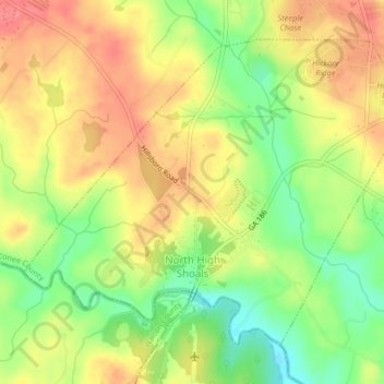
Nombre: Mapa topográfico North High Shoals, altitud, relieve.
Lugar: North High Shoals, Oconee County, Georgia, United States (33.81319 -83.52389 33.84010 -83.48327)
Altitud media: 214 m
Altitud mínima: 175 m
Altitud máxima: 246 m
Otros mapas topográficos
Haga clic en un mapa para ver su topografía, su altitud y su relieve.
Bogart
United States > Georgia > Oconee County
Bogart, Oconee County, Georgia, United States
Altitud media: 244 m
Watkinsville
United States > Georgia > Oconee County
Watkinsville, Oconee County, Georgia, 30644, United States
Altitud media: 218 m