
Haz una donación
Mapa topográfico Norfolk
Haga clic en el mapa para ver la altitud.
Haz una donación
Norfolk
According to the United States Census Bureau, the town has a total area of 46.4 square miles (120.2 km2), of which 45.3 square miles (117.4 km2) are land and 1.1 square miles (2.9 km2), or 2.38%, are water. The town is located in the Litchfield Hills portion of the Appalachian mountain range. Norfolk's elevation is 1,230 feet (370 m) above sea level, and the town is sometimes called "the Icebox of Connecticut" for its severe winters and particularly cool summers.
Haz una donación
Acerca de este mapa
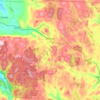
Nombre: Mapa topográfico Norfolk, altitud, relieve.
Altitud media: 404 m
Altitud mínima: 203 m
Altitud máxima: 559 m
Haz una donación
Otros mapas topográficos
Haga clic en un mapa para ver su topografía, su altitud y su relieve.
Apple Hill
United States > Connecticut > Northwest Hills Planning Region > Morris
Altitud media: 297 m
Northfield
United States > Connecticut > Northwest Hills Planning Region > Litchfield
Altitud media: 259 m
Bakerville
United States > Connecticut > Northwest Hills Planning Region > New Hartford
Altitud media: 244 m
Haystack Mountain
United States > Connecticut > Northwest Hills Planning Region > Norfolk
Altitud media: 385 m
Haz una donación
Marble Dale
United States > Connecticut > Northwest Hills Planning Region > Washington
Altitud media: 249 m
Washington Depot
United States > Connecticut > Northwest Hills Planning Region > Washington
Altitud media: 231 m
Nelsons Corner
United States > Connecticut > Northwest Hills Planning Region > Winchester
Altitud media: 275 m
Nepaug
United States > Connecticut > Northwest Hills Planning Region > New Hartford
Altitud media: 222 m
Haz una donación
West Torrington
United States > Connecticut > Northwest Hills Planning Region > Torrington
Altitud media: 270 m
Lakeville
United States > Connecticut > Northwest Hills Planning Region > Salisbury
Altitud media: 259 m
East Morris
United States > Connecticut > Northwest Hills Planning Region > Morris
Altitud media: 294 m
Wangum Village
United States > Connecticut > Northwest Hills Planning Region > Canaan
Altitud media: 235 m
Haz una donación
Pleasant Valley
United States > Connecticut > Northwest Hills Planning Region > Barkhamsted
Altitud media: 192 m
Drakeville
United States > Connecticut > Northwest Hills Planning Region > Torrington
Altitud media: 309 m
Bartholomew Hill
United States > Connecticut > Northwest Hills Planning Region > Goshen
Altitud media: 426 m
Haz una donación
Bear Mountain
United States > Connecticut > Northwest Hills Planning Region > Salisbury
Bear Mountain is a peak of the southern Taconic Mountains in Salisbury, Connecticut. At 2,316 feet (706 m) (note, per references 1 and 3, there is disagreement about the precise elevation), Bear Mountain is the highest mountain that lies wholly within Connecticut. However, it is not the state highpoint: in the…
Altitud media: 544 m
Canaan Valley
United States > Connecticut > Northwest Hills Planning Region > North Canaan
Altitud media: 293 m
Bear Mountain
United States > Connecticut > Northwest Hills Planning Region > Salisbury
Bear Mountain is a peak of the southern Taconic Mountains in Salisbury, Connecticut. At 2,316 feet (706 m) (note, per references 1 and 3, there is disagreement about the precise elevation), Bear Mountain is the highest mountain that lies wholly within Connecticut. However, it is not the state highpoint: in the…
Altitud media: 544 m
Haz una donación
The Matterhorn
United States > Connecticut > Northwest Hills Planning Region > Canaan
Altitud media: 462 m
The Matterhorn
United States > Connecticut > Northwest Hills Planning Region > Canaan
Altitud media: 462 m
Northfield
United States > Connecticut > Northwest Hills Planning Region > Litchfield
Altitud media: 259 m
Lime Rock
United States > Connecticut > Northwest Hills Planning Region > Salisbury
Altitud media: 238 m
Haz una donación
Bradford Mountain
United States > Connecticut > Northwest Hills Planning Region > Canaan
Altitud media: 470 m
Bulls Bridge
United States > Connecticut > Northwest Hills Planning Region > Kent
Altitud media: 178 m
Panorama Hill
United States > Connecticut > Northwest Hills Planning Region > Colebrook
Altitud media: 379 m
Bear Mountain
United States > Connecticut > Northwest Hills Planning Region > Salisbury
Bear Mountain is a peak of the southern Taconic Mountains in Salisbury, Connecticut. At 2,316 feet (706 m) (note, per references 1 and 3, there is disagreement about the precise elevation), Bear Mountain is the highest mountain that lies wholly within Connecticut. However, it is not the state highpoint: in the…
Altitud media: 544 m
Haz una donación
Town Hill
United States > Connecticut > Northwest Hills Planning Region > New Hartford
Altitud media: 255 m
Torringford
United States > Connecticut > Northwest Hills Planning Region > Torrington
Altitud media: 301 m
Bear Mountain
United States > Connecticut > Northwest Hills Planning Region > Salisbury
Bear Mountain is a peak of the southern Taconic Mountains in Salisbury, Connecticut. At 2,316 feet (706 m) (note, per references 1 and 3, there is disagreement about the precise elevation), Bear Mountain is the highest mountain that lies wholly within Connecticut. However, it is not the state highpoint: in the…
Altitud media: 544 m
Northfield
United States > Connecticut > Northwest Hills Planning Region > Litchfield
Altitud media: 259 m
Haz una donación
Grand Staircase
United States > Connecticut > Northwest Hills Planning Region > Kent
Altitud media: 205 m
Milton Hill
United States > Connecticut > Northwest Hills Planning Region > Goshen
Altitud media: 368 m
Apple Hill
United States > Connecticut > Northwest Hills Planning Region > Morris
Altitud media: 297 m
Canaan Valley
United States > Connecticut > Northwest Hills Planning Region > North Canaan
Altitud media: 293 m
Haz una donación
Burrville
United States > Connecticut > Northwest Hills Planning Region > Torrington
Altitud media: 292 m