
Haz una donación
Mapa topográfico Whites Bay
Haga clic en el mapa para ver la altitud.
Haz una donación
Acerca de este mapa
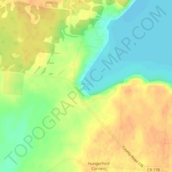
Nombre: Mapa topográfico Whites Bay, altitud, relieve.
Altitud media: 91 m
Altitud mínima: 72 m
Altitud máxima: 107 m
Haz una donación
Otros mapas topográficos
Haga clic en un mapa para ver su topografía, su altitud y su relieve.
City of Watertown
United States > New York > Jefferson County
Watertown is around 60 miles (97 kilometers) northwest of Syracuse, 20 miles (32 kilometers) south of the Thousand Islands and 328 miles (530 kilometers) northwest of New York City. According to the United States Census Bureau, the city has a total area of 9.3 square miles (24 km2), of which 9.0 square miles…
Altitud media: 150 m
Haz una donación
Village of Cape Vincent
United States > New York > Jefferson County > Town of Cape Vincent
Altitud media: 84 m
Haz una donación
City of Watertown
United States > New York > Jefferson County
Watertown is around 60 miles (97 kilometers) northwest of Syracuse, 20 miles (32 kilometers) south of the Thousand Islands and 328 miles (530 kilometers) northwest of New York City. According to the United States Census Bureau, the city has a total area of 9.3 square miles (24 km2), of which 9.0 square miles…
Altitud media: 150 m
Haz una donación
Haz una donación
City of Watertown
United States > New York > Jefferson County
Watertown is around 60 miles (97 kilometers) northwest of Syracuse, 20 miles (32 kilometers) south of the Thousand Islands and 328 miles (530 kilometers) northwest of New York City. According to the United States Census Bureau, the city has a total area of 9.3 square miles (24 km2), of which 9.0 square miles…
Altitud media: 150 m
Haz una donación
Just Room Enough Island
United States > New York > Jefferson County > Village of Alexandria Bay > Alexandria Bay
Altitud media: 78 m
Haz una donación