
Mapa topográfico Chennai
Mapa interactivo
Haga clic en el mapa para ver la altitud.
Acerca de este mapa
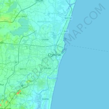
Nombre: Mapa topográfico Chennai, altitud, relieve.
Lugar: Chennai, Chennai District, Tamil Nadu, 600001, India (12.92369 80.11019 13.24369 80.43019)
Altitud media: 7 m
Altitud mínima: -2 m
Altitud máxima: 142 m
Chennai is located on the south–eastern coast of India in the north–eastern part of Tamil Nadu on a flat coastal plain known as the Eastern Coastal Plains. Its average elevation is around 6.7 metres (22 ft),[94] and its highest point is 60 m (200 ft).[95] Chennai is 2,184 kilometres (1,357 mi) south of Delhi, 1,337 kilometres (831 mi) southeast of Mumbai, and 1,707 kilometres (1,061 mi) southwest of Kolkata by road. Two major rivers flow through Chennai, the Cooum River (or Koovam) through the centre and the Adyar River to the south. A third river, the Kortalaiyar, travels through the northern fringes of the city before draining into the Bay of Bengal, at Ennore. The estuary of this river is heavily polluted with effluents released by the industries in the region.[96] Adyar and Cooum rivers are heavily polluted with effluents and waste from domestic and commercial sources, the Coumm being so heavily polluted it is regarded as the city's eyesore.[97][98] A protected estuary on the Adyar forms a natural habitat for several species of birds and animals.[99] The Buckingham Canal, 4 km (2.5 mi) inland, runs parallel to the coast, linking the two rivers. The Otteri Nullah, an east–west stream, runs through north Chennai and meets the Buckingham Canal at Basin Bridge. Several lakes of varying size are located on the western fringes of the city. Some areas of the city have the problem of excess iron content in groundwater.[100]
Otros mapas topográficos
Haga clic en un mapa para ver su topografía, su altitud y su relieve.
KOLLI HILLS
KOLLI HILLS, Namakkal District, Tamil Nadu, 637411, India
Altitud media: 563 m
Kallakurichi
India > Tamil Nadu > Kallakkurichi
Kallakurichi, Kallakkurichi, Kallakurichi District, Tamil Nadu, 606200, India
Altitud media: 124 m
Udhagamandalam
India > Tamil Nadu > Udhagamandalam
Udhagamandalam, The Nilgiris, The Nilgiris district, Tamil Nadu, 643001, India
Altitud media: 2.234 m
Varadarajapuram
India > Tamil Nadu > Varadarajapuram
Varadarajapuram, Thiruvallur, Thiruvallur district, Tamil Nadu, India
Altitud media: 24 m
Ward 171
India > Tamil Nadu > Chennai
Ward 171, Zone 13 Adyar, Chennai, Chennai district, Tamil Nadu, 600025, India
Altitud media: 11 m
Thanjavur
India > Tamil Nadu > Thanjavur
Thanjavur, Thanjavur district, Tamil Nadu, 613001, India
Altitud media: 49 m
Doddabetta
Doddabetta, The Nilgiris, The Nilgiris district, Tamil Nadu, 643001, India
Altitud media: 2.403 m
The Nilgiris
The Nilgiris, The Nilgiris district, Tamil Nadu, 643001, India
Altitud media: 679 m