
Mapa topográfico Salem
Mapa interactivo
Haga clic en el mapa para ver la altitud.
Acerca de este mapa
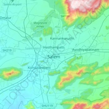
Nombre: Mapa topográfico Salem, altitud, relieve.
Lugar: Salem, Salem District, Tamil Nadu, India (11.53745 78.11011 11.78369 78.31861)
Altitud media: 400 m
Altitud mínima: 230 m
Altitud máxima: 1.456 m
Salem is located at 11°40′N 78°08′E / 11.67°N 78.14°E / 11.67; 78.14, at an average elevation of 278 m (912 ft.). The city is surrounded by hills: Nagaramalai on the north, Jarugumalai on the south, Kanjamalai on the west, Godumalai on the east and the Shevaroy Hills on the northeast. Kariyaperumal Hill is in southwestern Salem. The Thirumanimutharu River flows through the city, dividing it in two. The fort area is the oldest part of Salem.
Otros mapas topográficos
Haga clic en un mapa para ver su topografía, su altitud y su relieve.
KOLLI HILLS
KOLLI HILLS, Namakkal District, Tamil Nadu, 637411, India
Altitud media: 563 m
Kallakurichi
India > Tamil Nadu > Kallakkurichi
Kallakurichi, Kallakkurichi, Kallakurichi District, Tamil Nadu, 606200, India
Altitud media: 124 m
Udhagamandalam
India > Tamil Nadu > Udhagamandalam
Udhagamandalam, The Nilgiris, The Nilgiris district, Tamil Nadu, 643001, India
Altitud media: 2.234 m
Varadarajapuram
India > Tamil Nadu > Varadarajapuram
Varadarajapuram, Thiruvallur, Thiruvallur district, Tamil Nadu, India
Altitud media: 24 m
Ward 171
India > Tamil Nadu > Chennai
Ward 171, Zone 13 Adyar, Chennai, Chennai district, Tamil Nadu, 600025, India
Altitud media: 11 m
Thanjavur
India > Tamil Nadu > Thanjavur
Thanjavur, Thanjavur district, Tamil Nadu, 613001, India
Altitud media: 49 m
Doddabetta
Doddabetta, The Nilgiris, The Nilgiris district, Tamil Nadu, 643001, India
Altitud media: 2.403 m
The Nilgiris
The Nilgiris, The Nilgiris district, Tamil Nadu, 643001, India
Altitud media: 679 m