
Gracias por apoyar a este sitio ❤️
Haz una donación
Haz una donación
Mapa topográfico Walden
Haga clic en el mapa para ver la altitud.
Gracias por apoyar a este sitio ❤️
Haz una donación
Haz una donación
Walden
The highest point in Walden is the summit of Stannard Mountain, near the town's northern border, with an elevation of over 2,579 feet (786 m) above sea level.
Gracias por apoyar a este sitio ❤️
Haz una donación
Haz una donación
Acerca de este mapa
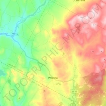
Nombre: Mapa topográfico Walden, altitud, relieve.
Lugar: Walden, Caledonia County, Vermont, 05873, United States (44.41970 -72.32139 44.54249 -72.15126)
Altitud media: 511 m
Altitud mínima: 283 m
Altitud máxima: 791 m
Gracias por apoyar a este sitio ❤️
Haz una donación
Haz una donación
Otros mapas topográficos
Haga clic en un mapa para ver su topografía, su altitud y su relieve.
Gracias por apoyar a este sitio ❤️
Haz una donación
Haz una donación
East Saint Johnsbury
United States > Vermont > Caledonia County > Saint Johnsbury
Altitud media: 311 m
Gracias por apoyar a este sitio ❤️
Haz una donación
Haz una donación
Gracias por apoyar a este sitio ❤️
Haz una donación
Haz una donación