
Haz una donación
Mapa topográfico Shelton
Haga clic en el mapa para ver la altitud.
Haz una donación
Acerca de este mapa
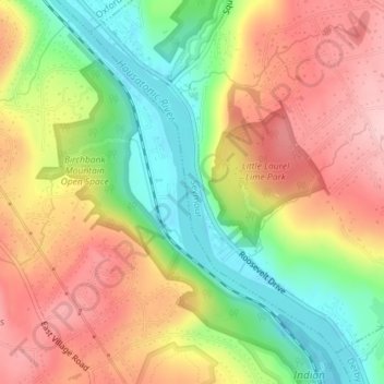
Nombre: Mapa topográfico Shelton, altitud, relieve.
Altitud media: 96 m
Altitud mínima: 1 m
Altitud máxima: 185 m
Haz una donación
Otros mapas topográficos
Haga clic en un mapa para ver su topografía, su altitud y su relieve.
Derby
United States > Connecticut > Naugatuck Valley Planning Region
According to the United States Census Bureau, the town has a total area of 5.4 square miles (8.7 km2), of which, 5.0 square miles (13 km2) is land and 0.4 square miles (1.0 km2) (7.41%) is water. The city is home to the 417 acres (0.652 sq mi) Osbornedale State Park. Derby is divided into two main sections by…
Altitud media: 78 m
Huntington
United States > Connecticut > Naugatuck Valley Planning Region > Shelton
Altitud media: 111 m
Haz una donación
Naugatuck State Forest
United States > Connecticut > Naugatuck Valley Planning Region > Beacon Falls
Altitud media: 137 m
Minortown
United States > Connecticut > Naugatuck Valley Planning Region > Woodbury
Altitud media: 169 m
Haz una donación
Wolcott
United States > Connecticut > Naugatuck Valley Planning Region
The highest point in New Haven County is found in Wolcott atop Lindsley Hill, which has an elevation of approximately 1,046 feet above sea level.
Altitud media: 209 m
Watertown
United States > Connecticut > Naugatuck Valley Planning Region
Watertown is in southeastern Litchfield County and is bordered to the southeast by the city of Waterbury in New Haven County. Other bordering towns are Middlebury to the south, Woodbury and Bethlehem to the west, Morris to the northwest, and Thomaston to the east. It is in the Eastern Standard time zone. The…
Altitud media: 199 m
Haz una donación
Prospect
United States > Connecticut > Naugatuck Valley Planning Region
According to the Köppen classification, Prospect is Dfb, or a humid continental climate. The town has warm and humid summers with cold winters. Precipitation is spread throughout the year, with thunderstorms frequent during the summer months, and heavy snowfalls during the winter months. Due to Prospect's…
Altitud media: 193 m
Oakville
United States > Connecticut > Naugatuck Valley Planning Region > Watertown > Oakville
Altitud media: 172 m
Haz una donación
White Hills
United States > Connecticut > Naugatuck Valley Planning Region > Shelton
Altitud media: 124 m
Haz una donación
Haz una donación
Prospect
United States > Connecticut > Naugatuck Valley Planning Region
According to the Köppen classification, Prospect is Dfb, or a humid continental climate. The town has warm and humid summers with cold winters. Precipitation is spread throughout the year, with thunderstorms frequent during the summer months, and heavy snowfalls during the winter months. Due to Prospect's…
Altitud media: 193 m
Haz una donación
Wolcott
United States > Connecticut > Naugatuck Valley Planning Region
The highest point in New Haven County is found in Wolcott atop Lindsley Hill, which has an elevation of approximately 1,046 feet above sea level.
Altitud media: 209 m
Traditions
United States > Connecticut > Naugatuck Valley Planning Region > Southbury > South Britain
Altitud media: 112 m
Haz una donación
Fox Hollow
United States > Connecticut > Naugatuck Valley Planning Region > Cheshire
Altitud media: 64 m
Westview Heights
United States > Connecticut > Naugatuck Valley Planning Region > Middlebury
Altitud media: 159 m
Union City
United States > Connecticut > Naugatuck Valley Planning Region > Naugatuck
Altitud media: 124 m
Haz una donación
Warsaw Park
United States > Connecticut > Naugatuck Valley Planning Region > Ansonia
Altitud media: 107 m
Bunker Hill
United States > Connecticut > Naugatuck Valley Planning Region > Waterbury
Altitud media: 140 m
Cedar Land
United States > Connecticut > Naugatuck Valley Planning Region > Southbury
Altitud media: 103 m
Town Plot Hill
United States > Connecticut > Naugatuck Valley Planning Region > Waterbury
Altitud media: 127 m
Haz una donación
Millville
United States > Connecticut > Naugatuck Valley Planning Region > Naugatuck
Altitud media: 132 m
Bunker Hill
United States > Connecticut > Naugatuck Valley Planning Region > Waterbury
Altitud media: 140 m
Bunker Hill
United States > Connecticut > Naugatuck Valley Planning Region > Waterbury
Altitud media: 140 m
Haz una donación
Minortown
United States > Connecticut > Naugatuck Valley Planning Region > Woodbury
Altitud media: 169 m
Haz una donación
Derby
United States > Connecticut > Naugatuck Valley Planning Region
According to the United States Census Bureau, the town has a total area of 5.4 square miles (8.7 km2), of which, 5.0 square miles (13 km2) is land and 0.4 square miles (1.0 km2) (7.41%) is water. The city is home to the 417 acres (0.652 sq mi) Osbornedale State Park. Derby is divided into two main sections by…
Altitud media: 78 m
Wolcott
United States > Connecticut > Naugatuck Valley Planning Region
The highest point in New Haven County is found in Wolcott atop Lindsley Hill, which has an elevation of approximately 1,046 feet above sea level.
Altitud media: 209 m
Gulls Hollow
United States > Connecticut > Naugatuck Valley Planning Region > Bethlehem
Altitud media: 243 m
Allentown
United States > Connecticut > Naugatuck Valley Planning Region > Plymouth
Altitud media: 244 m
Haz una donación
Haz una donación