
Haz una donación
Mapa topográfico Prospect
Haga clic en el mapa para ver la altitud.
Haz una donación
Prospect
According to the Köppen classification, Prospect is Dfb, or a humid continental climate. The town has warm and humid summers with cold winters. Precipitation is spread throughout the year, with thunderstorms frequent during the summer months, and heavy snowfalls during the winter months. Due to Prospect's elevation and location, temperatures are often colder, leading to snow in the town while lower towns to its east have rain. Like Connecticut, Prospect frequently experiences Nor'easters and Blizzards during the winter, which can bring heavy snowfall to the town.
Haz una donación
Acerca de este mapa
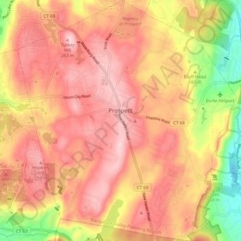
Nombre: Mapa topográfico Prospect, altitud, relieve.
Altitud media: 193 m
Altitud mínima: 44 m
Altitud máxima: 279 m
Haz una donación
Otros mapas topográficos
Haga clic en un mapa para ver su topografía, su altitud y su relieve.
Huntington
United States > Connecticut > Naugatuck Valley Planning Region > Shelton
Altitud media: 111 m
Minortown
United States > Connecticut > Naugatuck Valley Planning Region > Woodbury
Altitud media: 169 m
White Hills
United States > Connecticut > Naugatuck Valley Planning Region > Shelton
Altitud media: 124 m
Haz una donación
Mad River
United States > Connecticut > Naugatuck Valley Planning Region > Waterbury > Fair Lawn
Altitud media: 134 m
Traditions
United States > Connecticut > Naugatuck Valley Planning Region > Southbury > South Britain
Altitud media: 112 m
Fox Hollow
United States > Connecticut > Naugatuck Valley Planning Region > Cheshire
Altitud media: 64 m
Westview Heights
United States > Connecticut > Naugatuck Valley Planning Region > Middlebury
Altitud media: 159 m
Haz una donación
Union City
United States > Connecticut > Naugatuck Valley Planning Region > Naugatuck
Altitud media: 124 m
Warsaw Park
United States > Connecticut > Naugatuck Valley Planning Region > Ansonia
Altitud media: 107 m
Bunker Hill
United States > Connecticut > Naugatuck Valley Planning Region > Waterbury
Altitud media: 140 m
Haz una donación
Cedar Land
United States > Connecticut > Naugatuck Valley Planning Region > Southbury
Altitud media: 103 m
Town Plot Hill
United States > Connecticut > Naugatuck Valley Planning Region > Waterbury
Altitud media: 127 m
Millville
United States > Connecticut > Naugatuck Valley Planning Region > Naugatuck
Altitud media: 132 m
Bunker Hill
United States > Connecticut > Naugatuck Valley Planning Region > Waterbury
Altitud media: 140 m
Haz una donación
Bunker Hill
United States > Connecticut > Naugatuck Valley Planning Region > Waterbury
Altitud media: 140 m
Minortown
United States > Connecticut > Naugatuck Valley Planning Region > Woodbury
Altitud media: 169 m
Gulls Hollow
United States > Connecticut > Naugatuck Valley Planning Region > Bethlehem
Altitud media: 243 m
Allentown
United States > Connecticut > Naugatuck Valley Planning Region > Plymouth
Altitud media: 244 m
Haz una donación