
Haz una donación
Mapa topográfico Mount Fairweather
Haga clic en el mapa para ver la altitud.
Haz una donación
Mount Fairweather
Mount Fairweather (or Tsalxaan in the Tlingit language) is a mountain located 20 km (12 mi) east of the Pacific Ocean on the Canada–United States border. With an elevation of 4,653 metres (15,266 ft), it is the tallest mountain in British Columbia and the seventh-tallest mountain in both Alaska and the United States. Fairweather is part of the Saint Elias Mountains and mostly lies within Glacier Bay National Park and Preserve, though the summit borders Tatshenshini-Alsek Provincial Park.
Haz una donación
Acerca de este mapa
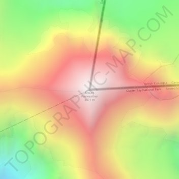
Nombre: Mapa topográfico Mount Fairweather, altitud, relieve.
Lugar: Mount Fairweather, Yakutat, Alaska, United States (58.90632 -137.52616 58.90642 -137.52606)
Altitud media: 3.845 m
Altitud mínima: 2.862 m
Altitud máxima: 4.668 m
Haz una donación
Otros mapas topográficos
Haga clic en un mapa para ver su topografía, su altitud y su relieve.
Hubbard Glacier
United States > Alaska > Yakutat
The longest source for Hubbard Glacier originates 122 kilometres (76 mi) from its snout and is located at about 61°00′N 140°09′W / 61.000°N 140.150°W / 61.000; -140.150, approximately 8 kilometres (5 mi) west of Mount Walsh with an elevation around 3,400 metres (11,200 ft). A shorter tributary…
Altitud media: 1.892 m
Malaspina Glacier
United States > Alaska > Yakutat
The Malaspina is up to 600 meters (2,000 ft) thick in places, with the elevation of its bottom being estimated to be as much as 300 m (980 ft) below sea level. There are two lakes on its margins: Oily Lake to the northwest, at the foot of the Samovar Hills between the Agassiz and Seward glaciers, and Malaspina…
Altitud media: 393 m
Haz una donación
Hubbard Glacier
United States > Alaska > Yakutat
The longest source for Hubbard Glacier originates 122 kilometres (76 mi) from its snout and is located at about 61°00′N 140°09′W / 61.000°N 140.150°W / 61.000; -140.150, approximately 8 kilometres (5 mi) west of Mount Walsh with an elevation around 3,400 metres (11,200 ft). A shorter tributary…
Altitud media: 1.892 m
Malaspina Glacier
United States > Alaska > Yakutat
The Malaspina is up to 600 meters (2,000 ft) thick in places, with the elevation of its bottom being estimated to be as much as 300 m (980 ft) below sea level. There are two lakes on its margins: Oily Lake to the northwest, at the foot of the Samovar Hills between the Agassiz and Seward glaciers, and Malaspina…
Altitud media: 393 m