
Haz una donación
Mapa topográfico Hubbard Glacier
Haga clic en el mapa para ver la altitud.
Haz una donación
Hubbard Glacier
The longest source for Hubbard Glacier originates 122 kilometres (76 mi) from its snout and is located at about 61°00′N 140°09′W / 61.000°N 140.150°W / 61.000; -140.150, approximately 8 kilometres (5 mi) west of Mount Walsh with an elevation around 3,400 metres (11,200 ft). A shorter tributary glacier begins at the easternmost summit on the Mount Logan ridge at about 5,600 metres (18,400 ft) at about 60°35′0″N 140°22′40″W / 60.58333°N 140.37778°W / 60.58333; -140.37778.
Haz una donación
Acerca de este mapa
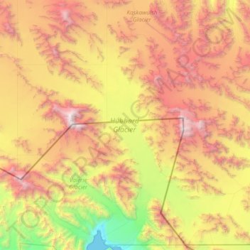
Nombre: Mapa topográfico Hubbard Glacier, altitud, relieve.
Lugar: Hubbard Glacier, Yakutat, Alaska, United States (59.98639 -139.66254 60.67720 -138.78555)
Altitud media: 1.892 m
Altitud mínima: 0 m
Altitud máxima: 4.763 m
Haz una donación
Otros mapas topográficos
Haga clic en un mapa para ver su topografía, su altitud y su relieve.
Mount Steller
United States > Alaska > Yakutat
Due to its isolated location, poor weather, and comparatively low absolute elevation by Alaskan standards, Mount Steller was not climbed until recently. The first ascent was in 1992.
Altitud media: 2.578 m
Mount Fairweather
United States > Alaska > Yakutat
Mount Fairweather (or Tsalxaan in the Tlingit language) is a mountain located 20 km (12 mi) east of the Pacific Ocean on the Canada–United States border. With an elevation of 4,653 metres (15,266 ft), it is the tallest mountain in British Columbia and the seventh-tallest mountain in both Alaska and the…
Altitud media: 3.845 m
Malaspina Glacier
United States > Alaska > Yakutat
The Malaspina is up to 600 meters (2,000 ft) thick in places, with the elevation of its bottom being estimated to be as much as 300 m (980 ft) below sea level. There are two lakes on its margins: Oily Lake to the northwest, at the foot of the Samovar Hills between the Agassiz and Seward glaciers, and Malaspina…
Altitud media: 393 m
Haz una donación
Mount Fairweather
United States > Alaska > Yakutat
Mount Fairweather (or Tsalxaan in the Tlingit language) is a mountain located 20 km (12 mi) east of the Pacific Ocean on the Canada–United States border. With an elevation of 4,653 metres (15,266 ft), it is the tallest mountain in British Columbia and the seventh-tallest mountain in both Alaska and the…
Altitud media: 3.845 m
Haz una donación
Malaspina Glacier
United States > Alaska > Yakutat
The Malaspina is up to 600 meters (2,000 ft) thick in places, with the elevation of its bottom being estimated to be as much as 300 m (980 ft) below sea level. There are two lakes on its margins: Oily Lake to the northwest, at the foot of the Samovar Hills between the Agassiz and Seward glaciers, and Malaspina…
Altitud media: 393 m